DRI’s Behind the Science Blog continues with the fourth and last installment of our fall 2022 Research Immersion Internship Series
This fall, DRI brought eleven students from Nevada’s community and state colleges to the Las Vegas and Reno campuses for a paid, immersive research experience. Over the course of the 16-week program, students worked under the mentorship of DRI faculty members to learn about the process of using scientific research to solve real-world problems.
Our Behind the Science Blog is highlighting each research team’s accomplishments over a series of four stories. Previous stories covered: Tiffany Pereira’s interns as they tracked elusive desert tortoises in the desert of Las Vegas; Erick Bandala’s student interns on their quest to find solutions for communities struggling with high concentrations of fluorides in their drinking water; and Braimah Apambire’s interns seeking ways to improve clean drinking water access in Ghanaian communities.
In this story, we highlight the work of Phillips Nguyen and Alexius Jessup-Raju, two students from Truckee Meadows Community College, as they explore natural hazards and their impacts on house ownership and aquatic environments.
Student Researchers: Phillips Nguyen and Alexius Jessup-Raju
Faculty mentor: Steve Bacon, Ph.D., Associate Research Professor of Geology
As the driest state in the nation, we might assume that flooding is the least of Nevada’s concerns compared to drought and wildfires. But throughout our state’s history, flooding has proven to be of major concern in the Reno-Tahoe area. From flash flooding to snowmelt in spring, Northern Nevadans are no stranger to the warning signs. Despite flood management tips and tricks, an extra step is needed to understand and prepare for the long-term effects of natural hazards. While there are many resources dedicated to maintaining a flood-resistant community, environmental and geologic data are fundamental in reconstructing past events to inform our future.
Under the mentorship of Steve Bacon, student interns Phillips Nguyen and Alexius Jessup-Raju were tasked with identifying natural hazards to make assessments related to homeownership and property development in the Reno-Tahoe area. Using Google Earth, the interns were able to create, store, view, and interact with the geographic landscape and identify what natural hazards may be in proximity to the site studied.
NATURAL HAZARD ASSESSMENTS
Natural hazard assessments are used to identify areas where drought, wildfires, floods, and other natural events are likely to occur, how often they occur, and how severe the effects are on surrounding communities. Risk assessments are used to combine this information with that of human activity and property development. These assessments are crucial for businesses and homeowners as well as other land-use decisions.
However, the process of identifying and assessing natural hazards using geographic information systems (GIS) is no easy feat. The interns ran into challenges, but ultimately learned how to approach trial and error in the scientific process.
The first step in the process was finding a geological map they could use. From there, the interns referenced the research site’s coordinates to determine its precise location. Ultimately, the interns mapped a site based on its location within 100-year flood and fault zones and found that the site had a history of landslides and flooding. The site was also forested, making it prone to potential wildfires.
“We found that the site has a history of landslides,” said intern Phillips Nguyen. “That concerns me if I want to buy a property because I would have to ensure that the property is protected. There might also be some flooding in the potential future since this site also has a history of flooding in the past. And the nearby faults can potentially cause seismic activity in the area [which] indirectly affects the viability of the site.”
“This was a great location to learn about geologic hazards and how they may impact a site,” says Bacon, the interns’ faculty mentor, on how he identified the location for the interns to research. “Ultimately, the identification of specific geologic hazards needs to be considered when making a geologic hazard assessment.”
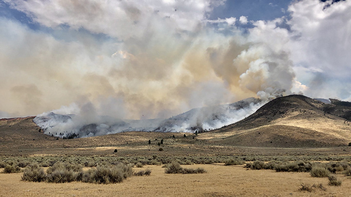
The Loyalton fire creeps down a hillside in Washoe County in September, 2020.
Credit: Jonathon Cook-Fisher/DRI.
ASSESSING WATER QUALITY
Flooding and other natural hazard events directly affect aquatic environments. The two interns looked at the impacts of natural hazards within the Silver State’s beloved blue gem– Lake Tahoe.
“The biggest impact on water quality is by humans,” said intern Alexius Jessup-Raju.
The types of water pollutants that can impact ecosystems during natural hazards range from garbage and ash, to fires, bacteria, and invasive species. Nitrogen and Phosphorus are other big pollutants that can result from fertilizer runoff that enters the lake from runoff and groundwater. “They can cause methemoglobinemia [which] inhibits your blood cells from producing oxygen,” Jessup-Raju said.
Aside from human health effects, polluted water can dramatically impact the health of underwater ecosystems.
“Phosphorous can cause algal pollutants to get out of control,” Alexius said. “When the algae die, they can cause dead zones — which are areas with no oxygen — and then other things can’t live there.”
IMPLICATIONS
By focusing on a specific site, determining if that site is viable for residential ownership, and understanding how water quality impacts aquatic environments in the Reno-Tahoe area, the two student interns were able to learn about geologic and environmental data and apply them to natural hazard assessments.
“That took some time because I wasn’t familiar with using Google Earth, so it was an experience using this software,” Nguyen said.
In addition to helping mold his interest in field work and water quality, Nguyen also noted that the experience “Taught me a lot about what my interests were because I wasn’t really sure what I wanted to do as a career, so this internship was really valuable.”
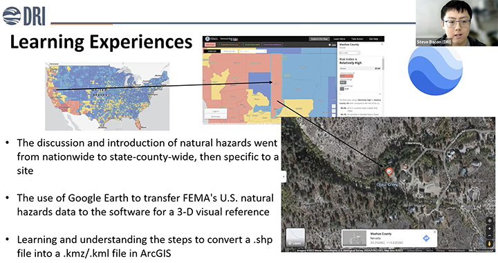
Above: Intern Phillips Nguyen presents his learning experiences from his internship.
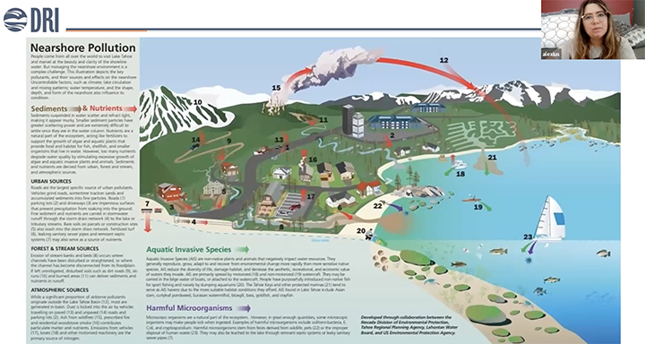
Above: Intern Alexius Jessup-Raju presents sources of aquatic pollution for Lake Tahoe.
More Information
To learn more about the DRI Research Immersion Internship, go to https://www.dri.edu/immersion/.
