California Snowlines On Track To Be 1,600 Feet Higher by Century’s End

California Snowlines On Track To Be 1,600 Feet Higher by Century’s End

California Snowlines On Track To Be 1,600 Feet Higher by Century’s End

May 30, 2023

Reno, Nev.

Shared with permission from Scripps Institution of Oceanography

Snowpack
Climate Change

DRI contributes to research concluding lower-elevation ski resorts could lose more than 70 percent of their natural snow supply

DRI’s Benjamin Hatchett, Ph.D, and Michael Dettinger, Ph.D., coauthored a new study in the journal Climate Dynamics that predicts dramatic changes for California’s future snowpack. The team combined seven decades of temperature and precipitation data with projections about climate change to examine the growing impact of atmospheric rivers, which tend to be warmer than other storms. With less snow in California’s future, there will be wide-ranging impacts on landscapes, ecosystems, and water availability for human communities. 

The snowline is an iconic component of mountains,” Hatchett says. “Its warming-driven upslope retreat poses numerous implications for the aspects of mountain environments we rely on for water resources, ecosystem function, and recreation. As the snowline moves upslope, increased winter runoff will occur at the expense of spring runoff, a change our current water management paradigm is not designed for. A longer snow-free environment will promote more severe wildfire activity at higher elevations and the numerous cascading impacts severe wildfire brings to ecosystems, life and property, and public health. Last, we will see recreation impacts such as shorter ski seasons, less available skiable terrain, and lower flows during the summer and fall, which when combined with other climate change impacts, negatively affects mountain economies.”

Below is the full press release from Scripps Institution of Oceanography. 


San Diego – March 25, 2023 –

This winter produced record snowfall in California, but a new study suggests the state should expect gradually declining snowpacks, even if punctuated with occasional epic snowfalls, in the future.

An analysis by Tamara Shulgina, Alexander Gershunov, and other climate scientists at UC San Diego’s Scripps Institution of Oceanography suggest that in the face of unabated global warming, the snowlines marking where rainfall turns to snow have been rising significantly over the past 70 years. Projections by the researchers suggest the trend will continue with snowlines rising hundreds of meters higher by the second half of this century. 

In the high Southern Sierra Nevada range, for instance, snowlines are projected to rise by more than 500 meters (1,600 feet) and even more when the mountains get precipitation from atmospheric rivers, jets of water vapor that are becoming an increasingly potent source of the state’s water supply. 

“In an average year, the snowpack will be increasingly confined to the peak of winter and to the highest elevations,” the study says.

Diminished snowfall is a consequence of a changing climate in which places like California will get an increasing portion of their winter precipitation as rain instead of snow. The authors said this study and related research suggest water resource managers will need to adapt to a feast-or-famine future. California’s water supply will arrive less through the gradual melt of mountain snowpack that gets the state through hot summers and more via bursts of rain and runoff delivered by atmospheric rivers, which are boosted by warming and are associated with higher snowlines than other storms.

Such events will further complicate the balancing act between protecting people and infrastructure from winter flooding and ensuring enough water supply during warmer summers.  

“This work adds insight into the climate change narrative of more rain and less snow,” said California Department of Water Resources (DWR) Climatologist Mike Anderson.  “DWR appreciates our partnership with Scripps to help water managers develop, refine, and implement adaptation efforts as the world continues to warm and climate change impacts are realized.”

The study, funded by the U.S. Bureau of Reclamation and the DWR, appears in the journal Climate Dynamics. 

“This is the longest and most detailed account of snow accumulation in California,” said Gershunov, “resolving individual storms over 70 years of observed weather combined with projections out to 2100.” 

The authors make note of what this could mean for ski resorts around the state if climate change progresses unabated. For example, Mammoth Mountain, at an elevation between 2,400 and 3,300 meters (7,900 – 11,000 feet), is projected to receive 28 percent less snowfall in the latter half of the century. Lower elevation ski resorts such as Palisades and Northstar, both near Lake Tahoe, span elevational ranges of around 1,900 and 2,700 meters (6,200 – 8,900 feet). They are projected to lose more than 70 percent of their snow accumulation in an average winter. 

“Observations and future climate projections show that already rising snowlines will keep lifting,” said Gershunov. “Epic winters will still be possible, though, and unprecedented snowfalls will ironically become more likely due to wetter atmospheric rivers, but they will be increasingly confined to the peak of winter and to the highest elevations of the Southern Sierra Nevada.” 

Study co-authors include Kristen Guirguis, Daniel Cayan, David Pierce, Michael Dettinger, and F. Martin Ralph of Scripps Oceanography, Benjamin Hatchett of the Desert Research Institute of Reno, Nev., Aneesh Subramanian of University of Colorado at Boulder, Steven Margulis and Yiwen Fang of UCLA, and Michael L. Anderson of the California Department of Water Resources.  


Scientists Discover Fire Records Embedded Within Sand Dunes

Scientists Discover Fire Records Embedded Within Sand Dunes

Scientists Discover Fire Records Embedded Within Sand Dunes

May 11, 2023

Reno, Nev.

Above: The Cooroibah wildfire sweeps down the Cooloola Sand Dunes in Australia. Photo by Michael Ford 

Fire History
Paleoclimate Research

The discovery could expand scientific understanding of fire histories
to arid regions around the world

Knowing how the frequency and intensity of wildfires has changed over time offers scientists a glimpse into Earth’s past landscapes, as well as an understanding of future climate change impacts. To reconstruct fire records, researchers rely heavily on sediment records from lake beds, but this means that fire histories from arid regions are often overlooked. Now, a new study shows that sand dunes can serve as repositories of fire history and aid in expanding scientific understanding of fire regimes around the world.
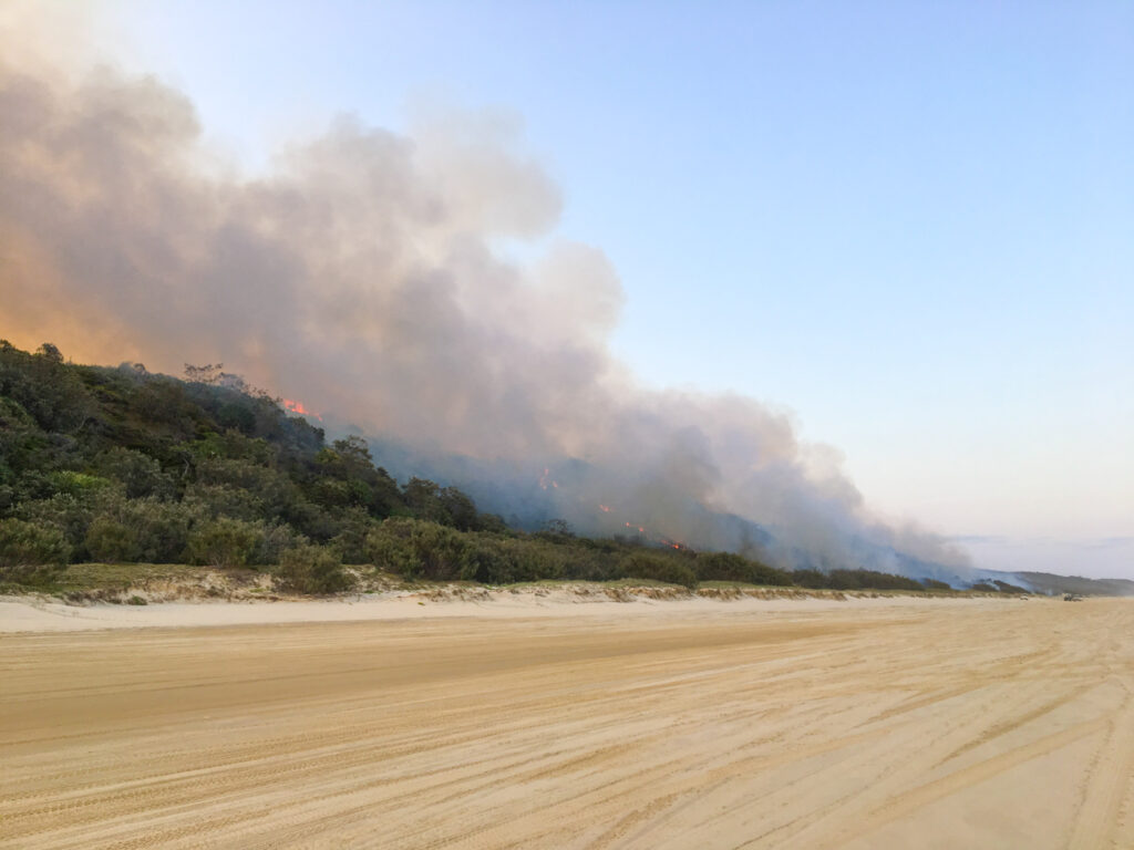
Published May 11 in Quaternary Research, the study is the first to examine sedimentary records preserved in foot-slope deposits of sand dunes. The research team, led by Nicholas Patton, Ph.D., a postdoctoral researcher now at DRI, studied four sand dunes at the Cooloola Sand Mass in Australia. Australia is one of the world’s most fire-prone landscapes, with a long history of both natural and cultural burning, and vast expanses without lakes or ponds to gather sedimentary records from. The researchers aimed to prove that these sand dune deposits could be used to reconstruct reliable, multi-millennial fire histories. These previously unrecognized archives could potentially be used in arid regions around the world to fill knowledge gaps in places where fire shapes the landscape.

“Many fire and paleoclimate records are located where there’s a lot of water bodies such as lakes, peats, and bogs,” Patton says. “And because of this, most global models really have a bias towards temperate regions.”

An illustration showing how charcoal layers accumulate in dune foot-slope deposits

Above: An illustration showing how charcoal layers accumulate in dune foot-slope deposits. Credit: Nicholas Patton/DRI

The Cooloola Sand Mass consists of enormous – up to 240-meter-tall – sand dunes that build up at the coast and gradually shift inland from the power of the wind. By identifying the age of the dunes using a technique called optically stimulated luminescence dating, or OSL, Patton’s team found that the four dunes span the Holocene, representing the last approximately 12,000 years.

Once a dune is stable, meaning it is no longer growing but slowly degrading, the force of gravity acts on the dune slopes to collect falling sand at the base, along with the remnants of charcoal from local fires that deposited on the dune’s surface. This sediment builds up over time, layering charcoal from fire events that can be reliably identified using radiocarbon dating.

“We were digging soil pits at the base of the dunes and were seeing a lot of charcoal – more charcoal than we expected,” says Patton. “And we thought maybe we could utilize these deposits to reconstruct local fires within the area.”

Patton found that on the younger dunes (at 500 years old and 2,000 years old), charcoal layers represented individual fires, because the steep slope of the dunes quickly buried each layer. However, the older dunes (at 5,000 years old and 10,000 years old) had more gradual slopes that blended charcoal from different fires over time, providing a better understanding of periods of increased or decreased fire frequency.

The dunes offered localized fire histories from within an approximate 100-meter radius, so fire records vary somewhat amongst the four dunes, which spanned approximately 2 kilometers. However, Patton’s team compared their results to other fire records from the region found in lake and swamp deposits. Similar to the regional records, their findings showed three major periods of fire activity over the past 7,000 years.

The researchers write that similar records are likely held in sand dunes around the world, and that regions like California and the Southwest U.S. could benefit from a better understanding of regional fire history. Embedded within the fire records is not only information about natural wildfires, but also the way that humans influenced fire regimes.

“Fire histories are important for understanding how fire was used in the past for cultural purposes, whether that was to clear fields for agriculture or for hunting,” Patton says.

Patton hopes to continue this line of research at other dunes near the Cooloola Sand Mass that are nearly 1 million years old to obtain a long-term fire history for the region. Because Australia has had human communities for at least 60-70 thousand years, and quite possibly longer, these records could help understand the relationship between humans and historical fire regimes.

“These kinds of long-term records aren’t always available within lake sediments, but they might be available within these dune deposits,” Patton says. “That’s pretty exciting.”


###


More information: The full study, Reconstructing Holocene fire records using dune foot-slope deposits at the Cooloola Sand Mass, Australia, is available from Quaternary Research.
DOI: https://doi.org/10.1017/qua.2023.14


Study authors include: Nicholas Patton (DRI/Univ. of Canterbury, NZ/Univ. of Queensland, AUS), James Shulmeister (Univ. of Canterbury, NZ/Univ. of Queensland, AUS), Quan Hua (Australian Nuclear Science and Technology Organization), Peter Almond (Lincoln University, NZ), Tammy Rittenour (Utah State Univ.), Johanna Hanson (Univ. of Canterbury, NZ), Aloysius Grealy (Univ. of Queensland, AUS), Jack Gilroy (Univ. of Queensland, AUS), Daniel Ellerton (Univ. of Queensland, AUS/Stockholm Univ.)


About DRI

The Desert Research Institute (DRI) is a recognized world leader in basic and applied environmental research. Committed to scientific excellence and integrity, DRI faculty, students who work alongside them, and staff have developed scientific knowledge and innovative technologies in research projects around the globe. Since 1959, DRI’s research has advanced scientific knowledge on topics ranging from humans’ impact on the environment to the environment’s impact on humans. DRI’s impactful science and inspiring solutions support Nevada’s diverse economy, provide science-based educational opportunities, and inform policymakers, business leaders, and community members. With campuses in Las Vegas and Reno, DRI serves as the non-profit research arm of the Nevada System of Higher Education. For more information, please visit www.dri.edu.


DRI Aims to Increase Scientific Access to Earth Monitoring Data With Re-Launch of ClimateEngine.org

DRI Aims to Increase Scientific Access to Earth Monitoring Data With Re-Launch of ClimateEngine.org

DRI Aims to Increase Scientific Access to Earth Monitoring Data With Re-Launch of ClimateEngine.Org

May 8, 2023

Reno, Nev.

Satellite Data
Climate Data

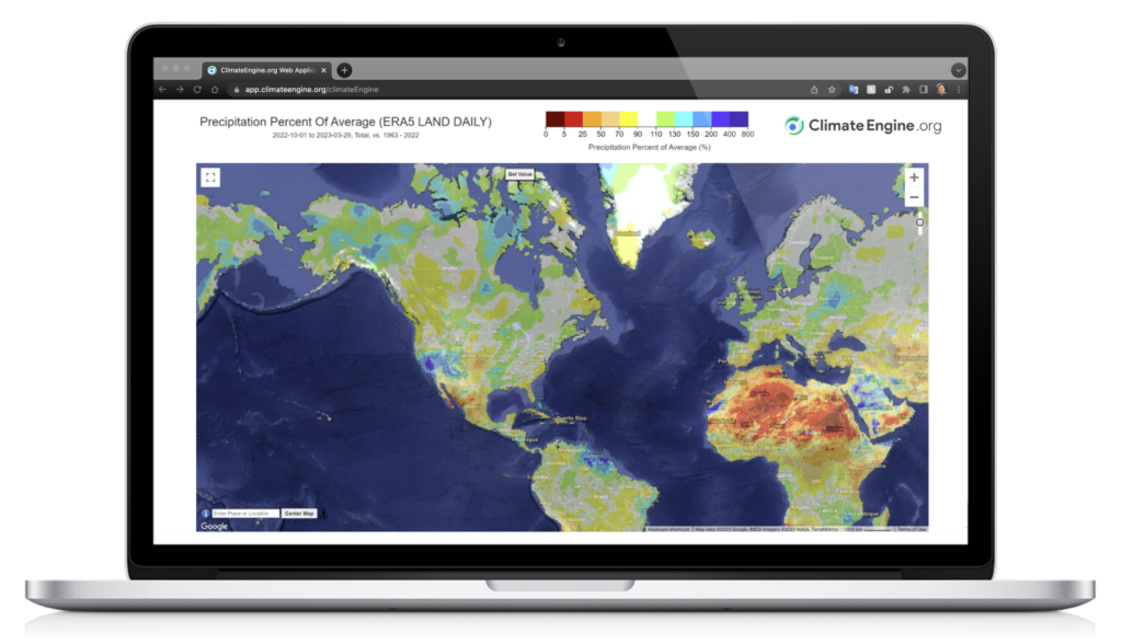
ClimateEngine.org allows researchers and natural resource managers to easily analyze and visualize complex satellite and climate data, helping users understand change  
in Earth’s landscapes over time  

The combined use of satellite and climate data has rapidly become critical for scientists and resource managers seeking to accurately assess changes in land cover and land use over time and across space. Unfortunately, processing such vast amounts of data can be time and cost-prohibitive, which is why researchers teamed up with Google and federal agencies to create ClimateEngine.org. Climate Engine’s innovative web application allows scientists, natural resource agencies, and other users to create maps and time series plots that integrate satellite and climate data, providing an indispensable — and free — tool for visualizing complex datasets.  

“If you’re trying to study how climate and natural resource management affects the environment, nothing beats the combination of maps and time series for unpacking the data,” says Justin Huntington, Ph.D., Climate Engine project lead and research professor of hydrology at DRI. 

First launched in 2016 at the White House Water Summit, ClimateEngine.org is being re-launched with new datasets, support resources, and functionality to increase the capabilities and user-friendliness of the site. Interactive maps and data visualizations produced using decades of satellite data have been a cornerstone of the ClimateEngine.org app, and the new updates will make it easier than ever to use satellite, climate, and forecast data together. These enhanced resources will help Climate Engine’s diverse user community — which includes 12,000+ registered users from public agencies, non-profits, research institutions, and tribal governments — to better use the app to produce charts and maps of environmental indicators such as drought, fire risk, vegetation condition, and agricultural water use.  

A global map showing drought variables from satellite data

Above: The Climate Engine web application provides on-demand mapping and plotting of hundreds of climate and satellite variables, enabling real-time analysis and monitoring of vegetation, drought, snowpack, and other important environmental conditions. 

“As researchers trying to process and visualize many Earth observations together, we understand how difficult it can be to work with these large and disjointed datasets,” Huntington says. “So, we wanted to create a tool that would allow researchers and practitioners to spend more time making discoveries and impact using the best available science.” 

The Climate Engine app is unique in that it enables users to visualize and analyze vast amounts of data without the need to code, and results can be downloaded, shared, and recreated with a simple link. It overcomes the computational barriers many research institutions and public agencies face when using large datasets by using Google Earth Engine’s parallel cloud computing platform. 

Notable datasets recently added include: 1) ERA5 Ag, which enables calculation of global drought, snowpack, and water demand indicators in near real-time; 2) Rangeland Analysis Platform, a 37-year Landsat dataset of vegetation cover and biomass production for the continental U.S.; and 3) OpenET monthly evapotranspiration, which provides Landsat satellite maps of vegetation water use at field-scale across the Western U.S. 

As one of Climate Engine’s primary partners, NOAA’s National Integrated Drought Information System (NIDIS) uses the Climate Engine Application Programming Interface (API) to automatically create drought datasets shared on Drought.gov  

“Climate Engine is a powerful cloud solution that has enabled NOAA to rapidly create and disseminate critical climate and drought information in ways that were previously impossible,” says Steve Ansari, physical scientist with NOAA’s National Centers for Environmental Information. “The initial Faculty Research Award by Google, followed by funding from NOAA-NIDIS and other federal agencies, has led to a very fruitful and rewarding public-private partnership.” This partnership will continue to produce new datasets, processing capabilities, stakeholder engagement, and web application and API enhancements to advance research, drought monitoring, and early warning. 

Map of the continental US showing drought severity with a color scale

Above: The Climate Engine API is used by NOAA’s National Integrated Drought Information System to automatically update real-time drought maps featured on Drought.gov. 

The Bureau of Land Management (BLM) was also an early supporter of ClimateEngine.org due to the agency’s need to adopt a more data-driven approach to monitoring drought and informing grazing decisions. BLM has positioned itself as a leader in monitoring of federal lands through its investment in ground and satellite-based vegetation monitoring. Among other contributions, the agency supported the development of fieldscale trends of drought and vegetation conditions within the Climate Engine web application. BLM is continuing to support trainings and integration of the newest datasets into Climate Engine to provide resource managers with the latest information and science on drought and vegetation conditions. 

A map of the Western US showing trends in vegetation cover

Above: Many advanced calculations are available within the Climate Engine web application, such as per-pixel trends and confidence levels that can be applied to all datasets, including Rangeland Analysis Platform vegetation cover and production data, to assess change over time.  

Moving forward this summer, the ClimateEngine.org team will be adding even more features and functionality to the app, further expanding access to the API, and hosting several public agency webinars and in-person workshops across the Western U.S.  

ClimateEngine.org is a collaboration between DRI, UC Merced, Google, and federal partners. The science team includes: DRI researchers Justin Huntington, Britta Daudert, Jody Hansen, Thomas Ott, Kristen O’Shea, Charles Morton, Dan McEvoy, and Eric Jensen, as well as UC Merced researchers Katherine Hegewisch and John Abatzaglou. Find out more about the initiative, partnerships, and updates at ClimateEngine.org and Twitter @ClimateEngOrg, and see the initiative’s peer-reviewed publication 


### 


About DRI 

The Desert Research Institute (DRI) is a recognized world leader in basic and applied environmental research. Committed to scientific excellence and integrity, DRI faculty, students who work alongside them, and staff have developed scientific knowledge and innovative technologies in research projects around the globe. Since 1959, DRI’s research has advanced scientific knowledge on topics ranging from humans’ impact on the environment to the environment’s impact on humans. DRI’s impactful science and inspiring solutions support Nevada’s diverse economy, provide science-based educational opportunities, and inform policymakers, business leaders, and community members. With campuses in Las Vegas and Reno, DRI serves as the non-profit research arm of the Nevada System of Higher Education. For more information, please visit www.dri.edu. 

Climate Change is Already Impacting Stream Flows Across the U.S. 

Climate Change is Already Impacting Stream Flows Across the U.S. 

Climate Change is Already Impacting Stream Flows Across the U.S. 

April 25, 2023

Reno, Nev.

Streamflow
Climate change

DRI researchers examined more than 500 watersheds across the country and found that increased winter temperatures are driving more extreme fluctuations in streamflow 

Climate change is here, and scientists continue to discover new ways that the world around us is changing. In a new study published in the May issue of the Journal of Hydrology, DRI researchers show that altered weather patterns are impacting stream flows across the country, with implications for flooding, drought, and ecosystems.  

Led by Abhinav Gupta, Ph.D., a Maki postdoctoral fellow at DRI, the research examined how day to day variations in streamflow changed in more than 500 watersheds in the U.S. between 1980 and 2013. They found that increased winter temperatures have driven the changes, with impacts varying due to local climate and amongst snow and rain-dominated watersheds. This information is important, the researchers say, for helping water managers adapt to climate change’s impacts.  

“We wanted to understand how climate change has impacted the hydrological balance across the U.S. based on the observed data,” Gupta says. “Once we understand how climate change has impacted stream flows in the recent past, we can figure out what kind of changes we might see in the future.” 

Streams receive water from a variety of sources, including fast, direct input from rainfall, and groundwater that gradually seeps through springs and soil. To understand how climate change is altering stream flows over time, the authors needed to differentiate between normal variability, like seasonal changes, and longer-term trends. To do this, they broke down stream inputs into events that occur at different timescales, like hourly and daily (rainfall), vs monthly and annual (groundwater). Then, they looked at trends for each timescale to see how they changed over time.  

“Once we understand how these trends are evolving, we can make educated guesses about what exactly is changing in the watershed – whether it is snowmelt, surface runoff, base flow, or one of many other factors,” says Gupta. “Without studying streamflow in this way (what is called streamflow statistical structure) it’s not possible to study all of these components together, at once.” 

Their results show that snow-dominated watersheds across the country are receiving more precipitation as rain than historically. This means that streams now have more water coming in short bursts from rainstorms, rather than the slow trickle of melting snow. The shift to short-term stream inputs could also be attributed to faster snowmelt rates due to higher temperatures, the authors say.  

“In the past, streamflow changed very slowly over time,” Gupta says. “But now, because of climate change, we have faster fluctuations in streamflow, which means that we can have a lot of water in a very small amount of time and then we can have no water for a long period of time. These extreme swings are occurring more and more.” 

Although the researchers found increased temperatures and changes in rainfall in all watersheds, differences in local climate dictate how this influences streamflow. In humid locales like Florida and the Pacific Northwest, storm inputs decreased, as higher temperatures caused more evaporation, leading the soil to absorb more rainwater. In the Great Plains and Mississippi Valley, contributions to streams from slow, long-term inputs like groundwater are very low, likely also due to high evaporation rates. Arid watersheds saw an increase in the number of days each year without rainfall over the study period, as well as a significant increase in winter temperatures, making streamflow more sporadic.  

The study didn’t examine other variables that could impact how water moves through watersheds, like changes in forest cover that impact the amount of water used by plants, or soil type, which affects how quickly rainfall permeates into groundwater. Because each watershed is unique, with its own recipe of soil type, climate, and forest cover, “we cannot paint everything with the same brush,” Gupta says. “We need different strategies for different watersheds to adapt to changes in climate. Even within the same region, watershed impacts can vary.” 

More research is needed, the study authors say, to understand what is driving changes in streamflow. If streams are increasingly dependent on groundwater, this could impact how water managers regulate groundwater pumping for human use. “That’s the kind of thing we need to know moving forward, in terms of how we manage our water resources,” says Sean McKenna, Ph.D., study co-author, and Clark J. Guild, Jr. Endowed Chair and Director of hydrologic sciences at DRI. “Can we pump more groundwater, or do we need to be more careful because if we do, we could lose streamflow?” 

Gupta says that he plans to build on this research. “Based on this study, we have been able to identify watersheds across the U.S. that have changed. Now that we know which watersheds in our dataset have been affected by climate change, we can look at the future changes in those watersheds.” 


More information: Changes in streamflow statistical structure across the United States due to recent climate change is available from the Journal of Hydrology. DOI: https://doi.org/10.1016/j.jhydrol.2023.129474 

Study authors include: DRI researchers Abhinav Gupta, Rosemary Carroll, and Sean McKenna 


### 


About DRI  

The Desert Research Institute (DRI) is a recognized world leader in basic and applied environmental research. Committed to scientific excellence and integrity, DRI faculty, students who work alongside them, and staff have developed scientific knowledge and innovative technologies in research projects around the globe. Since 1959, DRI’s research has advanced scientific knowledge on topics ranging from humans’ impact on the environment to the environment’s impact on humans. DRI’s impactful science and inspiring solutions support Nevada’s diverse economy, provide science-based educational opportunities, and inform policymakers, business leaders, and community members. With campuses in Las Vegas and Reno, DRI serves as the non-profit research arm of the Nevada System of Higher Education. For more information, please visit www.dri.edu. 

DRI and the Springs Preserve Launch Adult Science Education Series

DRI and the Springs Preserve Launch Adult Science Education Series

DRI and the Springs Preserve Launch Adult Science Education Series

April 4, 2023

Las Vegas, Nev.

Science at the Springs

Header Photo: The Springs Preserve in Las Vegas, NV. Photo by Renee Grayson (CC by 2.0)

DRI Science at the Springs –a new multimedia science storytelling series– explores environmental research, personal narratives, and climate solutions

DRI, in partnership with the Springs Preserve, announces the launch of DRI Science at the Springs. In the series, which launches on April 20, DRI scientists and other guests address some of the world’s most urgent concerns while also telling the tale of what it means to live in Nevada on the front lines of a changing climate. 

“We are excited to partner with the Springs Preserve in launching an adult science education opportunity, specifically related to weather, climate change, and resiliency,” said DRI President Kumud Acharya. “DRI Science at The Springs will explore environmental research, personal narratives, and climate solutions to address some of our most challenging environmental issues. We invite Southern Nevadans to join us for an unforgettable multimedia and storytelling experience that highlights the innovative research and solutions being implemented to address our pressing climate issues.” 

“We’re excited at the opportunity to join with DRI to expand on the educational programs presented at the Springs Preserve,” said Andy Belanger, director of public services. “This program provides an invaluable platform for us to continue educating and informing the community about the importance of science and how it touches our lives each day.” 

In 2023, DRI Science at the Springs will hold four events at the Springs Preserve’s Big Springs Theater:   


The Water Toolkit – Thursday, April 20, doors open at 6pm, presentation begins at 7pm 

As society grows increasingly concerned about the future of our water resources, DRI Science at the Springs offers a refreshing perspective. From the science of cloud seeding to the art of aquifer recharging, from the importance of urban forestry to the vital role of irrigation, this inaugural event is a unique opportunity to be at the forefront of the conversation about water and its future. 


The Art of Science – Thursday, June 15, doors open at 6pm, presentation begins at 7pm 

This evening is designed to highlight the intersection of creativity and science, and explore how the two often seemingly antithetical disciplines can lead to some of the most beautiful, innovative, and impactful solutions. This is a one-of-a-kind opportunity to broaden your understanding of the world and the role that science and art play in shaping it. You’ll leave the event with a deeper appreciation for the beauty that can be found in the scientific process, and how it can inspire us all to think more creatively about the world around us.  


History Written in Ice – Thursday, August 24, doors open at 6pm, presentation begins at 7pm 

This evening is dedicated to exploring the incredible story of ice core researchers and their journey to the arctic to extract ice cores that hold within them evidence of past societies, volcanic eruptions, and even plagues. You’ll learn about the incredible lengths that researchers go to in order to extract these cores, the technological advances that have made this work possible, and the impact that their discoveries have had on our understanding of history. 


Beyond the Horizon – Thursday, October 5, doors open at 6pm, presentation begins at 7pm  

In this final event in our season, DRI Science at the Springs departs from Earth and takes you on a journey to explore the beyond. Join our speakers as they share stories and research of hitchhikers on the International Space Station, how a symbiotic relationship between a fungus and bacteria might be the key ingredient in developing a sunscreen for the Red Planet and more. 

 DRI Science at the Springs is made possible through generous support from our sponsors Nevada Health Link and CORE Construction 


Ticket Types and Pricing: 

Single Event Pricing  

$25 Non-member  

$20 Springs Preserve Members  

$15 Springs Preserve Donor Members – (Gold and Platinum donor members receive a free pair of tickets to one of the four events) 


Series Pricing (tickets to all four speaking engagements, limited amount) 

$80 Non-members 

$65 Springs Preserve Members   

$50 Springs Preserve Members Donor Members 


Tickets may be purchased through the Springs Preserve website or at the door the evening of the event.  

 DRI Science at the Springs is an adult-only (over 21) event. There will be a no-host beer and wine bar and snack shop. Food and beverage are not included in the ticket price.  


### 


About DRI 

The Desert Research Institute (DRI) is a recognized world leader in basic and applied environmental research. Committed to scientific excellence and integrity, DRI faculty, students who work alongside them, and staff have developed scientific knowledge and innovative technologies in research projects around the globe. Since 1959, DRI’s research has advanced scientific knowledge on topics ranging from humans’ impact on the environment to the environment’s impact on humans. DRI’s impactful science and inspiring solutions support Nevada’s diverse economy, provide science-based educational opportunities, and inform policymakers, business leaders, and community members. With campuses in Las Vegas and Reno, DRI serves as the non-profit research arm of the Nevada System of Higher Education. For more information, please visit www.dri.edu. 


About Springs Preserve 

Located at the site of Las Vegas’ original water source, the Springs Preserve is a 180-acre cultural institution that celebrates Las Vegas’ dynamic history while focusing on its sustainable future. Visitors to the Springs Preserve will discover boundless opportunities to explore ancient and modern history, natural landscapes, archaeological sites, native plants and animals, and current water resource challenges. The campus includes the OriGen Museum, Nevada State Museum, two interactive exhibition spaces (WaterWorks and Boomtown 1905), a colorful botanical garden, art gallery, kids’ learning center, natural trails system, restored wetlands, seasonal butterfly habitat, preserved historical structures, and trackless train rides.. For more information, please visit www.springspreserve.org.  

A Reconstruction of Prehistoric Temperatures for Some of the Oldest Archaeological Sites in North America

A Reconstruction of Prehistoric Temperatures for Some of the Oldest Archaeological Sites in North America

A Reconstruction of Prehistoric Temperatures for Some of the Oldest Archaeological Sites in North America

March 29, 2023

Reno, Nev.

Paleoclimatology

Header Photo: View of autumn in Wrangell St. Elias National Park, Alaska

Scientists used a new technique that examines temperature records stored in bacteria to better understand the environmental conditions that may have led to the earliest human migrations into the Americas

 Scientists often look to the past for clues about how Earth’s landscapes might shift under a changing climate, and for insight into the migrations of human communities through time. A new study offers both by providing, for the first time, a reconstruction of prehistoric temperatures for some of the first known North American settlements.

The study, published in Quaternary Science Reviews, uses new techniques to examine the past climate of Alaska’s Tanana Valley. With a temperature record that reaches back 14,000 years, researchers now have a glimpse into the environment that supported humans living at some of the continent’s oldest archaeological sites, where mammoth bones are preserved alongside evidence of human occupation. Reconstructing the past environment can help scientists understand the importance of the region for human migration into the Americas.

“When you think about what was happening in the Last Glacial Maximum, all these regions on Earth were super cold, with massive ice sheets, but this area was never fully glaciated,” says Jennifer Kielhofer, Ph.D., a paleoclimatologist at DRI and lead author of the study. “We’re hypothesizing that if this area was comparatively warm maybe that would have been an attractive reason to come there and settle.”

Kielhofer conducted the research during her doctoral studies at the University of Arizona, and was attracted to the Alaska location because of the wealth of research expertise being focused on the area. She also saw an opportunity to contribute to scientific understanding of a part of the world that is particularly sensitive to global climate change.

“We have to look to the past to try to better constrain how these areas have responded previously,” she said, “and how they might respond in the future under climate scenarios that we predict.”

Earlier research had relied on coarse temperature records by examining changes in vegetation and pollen. However, this information can only provide a general sense of whether a region was warming or cooling over time. To obtain a more precise history of temperatures, Kielhofer examined soil samples from the archeological sites. Using a technique known as brGDGT paleothermometry, she examined temperature records stored in bacteria to obtain a record of mean annual air temperature above freezing with a precision within about 2.8 degrees Celsius.  

“Bacteria are everywhere,” she said. “That’s great because in areas where you might not have other means of recording or assessing past temperature, you have bacteria. They can preserve for millions of years, so it’s a great opportunity to look at pretty much anywhere on Earth.”  

The results were surprising, she said, because many scientists had previously believed that the region experienced large swings in temperature, which may have contributed to the movement of early humans. But Kielhofer’s data showed that temperatures in the Tanana Valley remained fairly stable over time.  

“The region wasn’t really responding to these global scale climate changes as we might expect,” she said. “Because temperatures are really stable through this record, we can’t necessarily use temperature as a way to explain changes in human occupation or adaptation through time, as scientists have previously tried to do.” 

Kielhofer’s now turning her attention to other historical records, like changes in aridity, that could help explain how conditions in this region influenced early human communities.   

### 


More information: The full study, BrGDGT temperature reconstruction from interior Alaska: Assessing 14,000 years of deglacial to Holocene temperature variability and potential effects on early human settlement, is available from Quaternary Science Reviews. https://doi.org/10.1016/j.quascirev.2023.107979 


Study authors include: Jennifer Kielhofer (DRI/University of Arizona), Jessica Tierney (Univ. of Arizona), Joshua Reuther (Museum of the North, Univ. of Alaska Fairbanks), Ben Potter and Charles Holmes (Univ. of Alaska Fairbanks), François Lanoë (Univ. of Arizona), Julie Esdale (Colorado State), Matthew Wooller and Nancy Bigelow (Univ. of Alaska Fairbanks).  

Jennifer Kielhofer takes careful samples from a soil pit in Alaska's Tanana Valley.

Above: Jennifer Kielhofer sampling for charcoal and biomarkers (GDGTs) at Keystone Dune in Alaska, one of the study sites as well as one of the older archaeological sites in the area (dating back ~13,000 years). 

New Study Sheds Light on Ancient Microbial Dark Matter

New Study Sheds Light on Ancient Microbial Dark Matter

New Study Sheds Light on Ancient Microbial Dark Matter

March 21, 2023

Reno, Nev.

Shared with permission from the University of Nevada, Las Vegas

Omnitrophota
Microbial Dark Matter

Header Photo: Obsidian Pool in Yellowstone National Park. Credit: Bob Lindstrom. Photo in the Public Domain

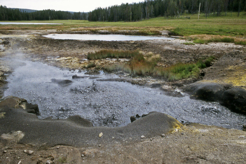
DRI contributes to international team of scientists that unearths first in-depth look at Omnitrophota, one of the world’s oldest and tiniest bacteria 

DRI’s Duane Moser, Ph.D., is a coauthor on a new study in Nature Microbiology that offers the first detailed analysis of a globally prominent, but poorly characterized type of bacteria belonging to a group scientists refer to as “microbial dark matter.” Formally described here for the first time as the Omnitrophota, the existence of this phylum of bacteria was first inferred from environmental DNA nearly thirty years ago.    

This paper illuminates the properties and ecological function of a group of ubiquitous, but poorly understood organisms,” said Moser, associate research professor of microbiology.  

Moser’s contribution to the study included identifying field sites and collecting samples, as well as developing an understanding of environmental context. His long-standing research relationship with the lead authors of the study meant that collaborative projects over the years led to a number of useful datasets for the analysis.  

“The research community has followed the Omnitrophota story since the 1990s, when earlier groundbreaking studies that revealed unexpected diversity within Archaea at Obsidian Pool in Yellowstone National Park were expanded to include bacteria,” Moser says. “In those days, full genomes of uncultivable microorganisms were beyond the reach of available technologies, so a conserved gene that encodes an essential structure shared by all cellular life (the 16S rRNA gene) was used to identify novel life and estimate relatedness between organisms.” 

“What scientists found was so different from anything that had been described previously that scientists of the time proposed that Omnitrophota might be a novel phylum within Bacteria (the equivalent of the evolutionary difference between plants and animals). This interpretation has stood the test of time,” Moser continued.  

“Over the past several decades, Omnitrophota has been frequently encountered in aquatic and soil samples worldwide. In our own work in springs, mines, and shallow groundwaters, Omnitrophota have often been among the more prominent microbial groups detected. I sometimes wonder if the sheer abundance and evident diversity of this omnipresent group has intimidated researchers from tackling its formal description. This was an ambitious project that required the combined expertise of a strong team of collaborators.”   

Brian Hedlund, a microbiologist at the University of Nevada, Las Vegas, and lead author of the study, said “Duane’s knowledge of the geology and hydrology of subsurface environments — and how to sample them meaningfully — was really important for this study.” 

Below is the full press release from the University of Nevada, Las Vegas.   


LAS VEGAS – March 16, 2023 – Bacteria are literally everywhere – in oceans, in soils, in extreme environments like hot springs, and even alongside and inside other organisms including humans. They’re nearly invisible, yet they play a big role in almost every facet of life on Earth.  

Despite their abundance, surprisingly little is known about many microorganisms that have existed for billions of years.  

This includes an entire lineage of nano-sized bacteria dubbed Omnitrophota. These bacteria, first discovered based on short fragments of DNA just 25 years ago, are common in many environments around the world but have been poorly understood. Until now.  

An international research team produced the first large-scale analysis of more than 400 newly sequenced and existing Omnitrophota genomes, uncovering new details about their biology and behavior. The team’s findings are reported in the March 16 issue of the journal Nature Microbiology 

“We now have the most comprehensive view to date of the biology of an entire phylum of microorganisms and the surprising role they play in the Earth’s ecosystems,” said UNLV microbiologist Brian Hedlund, the study’s corresponding author. “There is a finite number of major lineages of life on our planet, and it’s exciting to learn more about organisms that pre-date plants and animals and have been essentially hidden under our noses.”  

The tricky thing with Omnitrophota is that they’re still largely considered microbial dark matter, which means they exist in nature but can’t yet be cultivated as single species in lab studies. Just two species have been microscopically observed, and only very recently.  

To present a comprehensive picture of their biology, scientists compared 349 existing and 72 newly mapped genomes of Omnitrophota. This included a review of publicly available data and new samples collected from geothermal environments, freshwater lakes, wastewater, groundwater, and springs located around the world.   

The team observed that, in most cases, Omnitrophota measure less than 450 nanometers, which places them among the smallest of all known organisms. They also displayed genetic markers consistent with symbiosis – possibly as predators or parasites of other microorganisms, which suggested they would have high metabolic rates. Indeed, when isotope uptake was measured as a proxy for metabolic activity, Omnitrophota were hyperactive.  

“Despite how little we collectively knew about Omnitrophota, they’ve long been cited by microbial ecologists. Our goal was to finally drag this lineage out of the dark,” said Cale Seymour, a recent UNLV master’s graduate and the study’s lead author. “The more we learn about their energy conservation pathways and possible lifestyles, the closer we get to our goal of cultivating them in the lab and bringing them into the light.”  

The study, “Hyperactive nanobacteria with host-dependent traits pervade Omnitrophota,” appeared March 16 in the journal Nature Microbiology. Additional collaborating organizations include Bigelow Laboratory for Ocean Sciences, the University of North Alabama, the U.S. Department of Energy’s Joint Genome Institute, Desert Research Institute, Northern Arizona University, Sun Yat-sen University, University of Science and Technology of China, and University of Queensland. 


First-ever layered lake-sediment sample extracted from subglacial Antarctica

First-ever layered lake-sediment sample extracted from subglacial Antarctica

First-ever layered lake sediment sample extracted from subglacial Antarctica 

March 9, 2023

Golden, Colorado

Shared with permission from the Colorado School of Mines

Subglacial Lakes Antarctica
Header Photo Credit: Matthew Siegfried

Sample gives important details into past dynamics of the Antarctic ice sheet and its cold, dark ecosystems

DRI’s Mark Hausner, Ph.D., is a coauthor on a new study detailing the first layered lake-sediment sample taken from a subglacial lake in Antarctica. Hausner stepped in to assist the project team — dubbed SALSA for Subglacial Antarctic Lakes Scientific Access — after a difficult deployment created challenges in recovering temperature data from their equipment.

“I worked with the team after their return to recover the best temperature data we could,” Hausner says. Although precise temperature observations couldn’t be recovered, Hausner’s expertise with fiber-optic distributed temperature sensing cables enabled him to identify changes in the data that were consistent with other observations. 

“Using multiple observation methods really increases your confidence in what you’re seeing,” he says. “In this case, satellite observations, surface geophysics, and the temperature profile through the ice and into the lake all tell the same story of a lake underneath 1 km of ice that’s switching from draining to filling.”

Below is the full press release from the Colorado School of Mines.


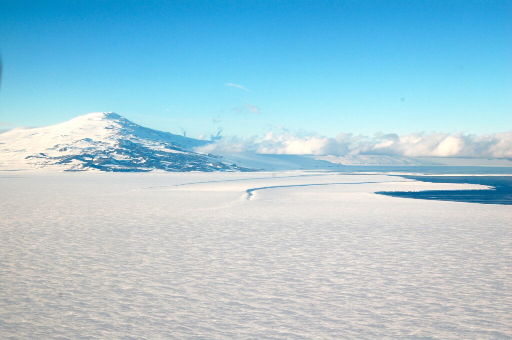
Since the discovery 50 years ago of subglacial lakes in Antarctica — some of the least accessible geological features on Earth — scientists have attempted to extract lake bed sediment to learn about the formation, movement, and past conditions of the ice sheet. Now, a team of researchers with the NSF-funded project Subglacial Antarctic Lakes Scientific Access (SALSA) has successfully done so, recovering the first layered sediments from beneath the modern Antarctic ice sheet.
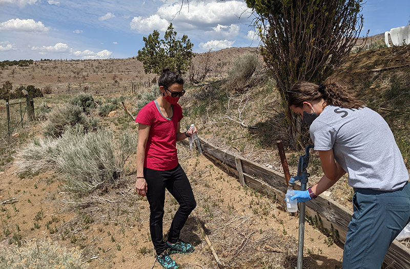
Their findings from analysis of the sediment sample, published March 9 in Geology, give important insight into the larger dynamics of the Antarctic ice sheet and its history, including when the ice sheet was smaller than its current size. Their work adds to the sedimentary record of knowledge of Antarctica and also holds implications for understanding how Antarctica may contribute to global sea level change.

Previous studies of modern subglacial lakes were limited to the timescale of the modern ice sheet due to the challenge of sampling an environment locked beneath thousands of feet of ice. The sediment sample extracted by the SALSA team will allow researchers to better understand subglacial activity across almost two centuries, instead of merely two decades.

“There are places on Earth that we still haven’t explored,” said Matthew Siegfried, assistant professor of geophysics at Colorado School of Mines and a lead author of the paper. “We have now one sample trying to understand an environment that is one and a half times the size of the continental United States. It’s like pulling up a rock in New Orleans and understanding how the Mississippi River and its entire basin has acted for the past 1,000 years.”

The saga of the SALSA team’s quest to explore subglacial lakes is chronicled in “The Lake at the Bottom of the World,” a feature-length documentary film released across multiple streaming platforms on February 28 by the team in partnership with Metamorph Films. The NSF-funded film gives viewers a close look at how the scientists conducted their work amid harsh Antarctic conditions.

‘Like grabbing a package of soup’

Researchers captured the sediment sample on a field expedition in December 2018. They cleanly bored a hole through over 3500 feet of ice over Mercer Subglacial Lake by filling a modified fire hose with sterilized water at nearly 200 °F and aiming it into the ice. They carefully collected sediment cores through a borehole that was constantly freezing back in using a device modified from its typical use in “normal” lakes to fit in a narrow ice borehole.

While researchers knew that even the mere extraction of the sediment from the lake would be a success, the fact that a sample arrived at the lab intact proved even more gratifying.

“We didn’t expect to find this mushy, fragile sediment under the ice sheet,” Siegfried said. “It was basically like grabbing a package of soup, bringing it up 1100 meters to the surface of the ice, shipping it to America, getting it into a CT scanner in Oregon, and somehow maintaining tiny laminations in the sample.”

Previous sediment samples from beneath the modern West Antarctic Ice Sheet have only consisted of a jumbled mixture of marine muds and rocks left behind when glaciers move over the Earth and do not contain a layered history of the region or ice sheet.

“In a 2001 paper published after a decade of subglacial drilling efforts in Antarctica, glaciologist Barclay Kamb somewhat unenthusiastically summarizes that everywhere the project sampled sediments, they found the same uninteresting, sticky, gray mixture,” said Ryan Venturelli, assistant professor of geology and geological engineering at Colorado School of Mines and a lead author on the paper.

“We found that, too. But above that same sticky, gray stuff, we found something different for the first time.”

Understanding subglacial movement

CT imagery of the sample showed a pattern of contrasts that indicated the subglacial lake was filling and draining with water before the scientists’ observational record. This finding offers insight into how long water has been moving under this part of Antarctica — movement that has implications for how the ice sheet moves and contributes to sea level rise. The life cycle of subglacial lakes derived from these contrasts also will enable researchers to better identify how carbon, nutrients and dissolved gasses are transported through the subglacial system to the global ocean.

“We use sediments from normal (subaerial) lakes all the time to build records of regional changes in climate. Subglacial lakes are different, because they are sealed by an overlying ice sheet that shields them from changing seasons and changing climate. Any variation in the subglacial sediment record is driven by changes to the overlying ice sheet and associated water system,” Venturelli said.

“Thanks to satellites that have helped us spy on Antarctica from space since 2003, we have a deep understanding of subglacial lake activity in the modern record, but the sediments we collected as part of SALSA give us an idea of how persistent these features are on a much longer timescale — hundreds of years. It’s our first insight into the life cycle of an active subglacial lake, and that is really exciting,” Venturelli added.

Significance of the sampling effort

The findings shared in Geology come amid more groundbreaking publications from the SALSA team based on the sediment samples they retrieved from Mercer Subglacial Lake. In February, researchers published work in ISME Communications that examined and compared microbial communities in the sediment to other regions under the ice; their work indicated an extensive subglacial ecosystem that is biogeochemically and evolutionarily linked through ice sheet behavior and the transport of microbes, water and sediments. Forthcoming research out soon in AGU Advances, also led by Venturelli, constrains the Antarctic subglacial carbon cycle for the first time and indicates how details of the cycle can be used to estimate how much smaller the West Antarctic Ice Sheet was in the last few thousand years.

“Knowing the dynamics of the ice sheet in the past is critical for predicting how it may respond to changes in the future, but this information has also helped to better understand the connectedness of these ecosystems to processes on the surface and regions beneath deep Antarctic ice that have yet to be explored,” said Brent Christner, a microbiologist at the University of Florida and SALSA Project team member.


Arsenic Contaminates Private Drinking Water Wells Across the Western Great Basin

Arsenic Contaminates Private Drinking Water Wells Across the Western Great Basin

Arsenic Contaminates Private Drinking Water Wells Across the Western Great Basin 

February 21, 2023
RENO, Nevada

Arsenic 
Water Wells
Western Great Basin

Above: Researchers test a private well water for traces as metals such as arsenic in Washoe Valley, Nevada. 

Credit: Monica Arienzo/DRI.

A New Study Maps Risk of Elevated Arsenic Levels in Groundwater Wells Across Northern Nevada, Northeastern California, and Western Utah


In the arid and drought-stricken western Great Basin, sparse surface water means rural communities often rely on private groundwater wells. Unlike municipal water systems, well water quality in private wells is unregulated, and a new study shows that more than 49 thousand well users across the region may be at risk of exposure to unhealthy levels of arsenic in drinking water.  

Led by researchers at DRI and the University of Hawai’i Cancer Center and published February 16th in Environmental Science and Technology, the study used data from groundwater wells across the western Great Basin to build a model to predict the probability of elevated arsenic in groundwater, and the location and number of private well users at risk. According to the study, the Carson Desert basin (including the town of Fallon, Nevada), Carson Valley (Minden and Gardnerville, Nevada), and the Truckee Meadows (Reno), have the highest population of well users at risk. The new study builds on previous research showing that 22% of 174 domestic wells sampled in Northern Nevada had arsenic levels exceeding the EPA guideline.  

“What we are finding is that in our region, we have a high probability for elevated arsenic compared to most other regions in the country,” said Daniel Saftner, M.S., a hydrogeologist at DRI and lead author of the study. “And we are seeing that geothermal and tectonic processes that are characteristic of the Great Basin contribute to the high concentrations of naturally occurring arsenic in the region’s groundwater.”   

The region’s mountains are also primary sources of arsenic. “As the arsenic-rich volcanic and meta-sedimentary rocks that form the mountains erode, sediment is transported to the valleys below,” says Steve Bacon, Ph.D., DRI geologist and study co-author. Water percolating through the valley floor then carries arsenic into the groundwater. Deeper, older groundwater and geothermal waters tend to have a higher arsenic concentration and can migrate upward along faults and mix with shallow groundwater. 

“We really wanted to better understand the unique geologic factors that contribute to high arsenic in this study,” Saftner says. “It’s important for us to think about the role of the environment as it pertains to human health – where we live can influence what our long-term health looks like.”  

To train and test the predictive model, the research team used data collected through the Healthy Nevada Project, including water samples from 163 domestic wells primarily located near Reno, Carson City, and Fallon. These data were supplemented with 749 groundwater samples compiled from the USGS National Water Information System. The model uses tectonic, geothermal, geologic, and hydrologic variables to predict the probability of elevated arsenic levels across the region.  

Although the U.S. EPA has set an arsenic concentration guideline of 10 µg/L for public drinking water, previous research has shown a range of health effects from long-term exposure to levels above 5 µg/L. Using this concentration as the benchmark, the model and map show that much of the region’s groundwater – particularly in western and central Nevada – is predicted to have more than a 50% probability of elevated arsenic levels.  

“Community members can use our arsenic hazard map to see what the risk is at their location, which might motivate them to test their well water,” says Monica Arienzo, Ph.D., associate research professor at DRI and study co-author. “Then, if they have high levels of arsenic or other contaminants, they can take steps to reduce their exposure, such as installing a water treatment system.”  

The findings from this study are potentially useful for a range of different applications. “The results can be useful for water utilities or water managers who tap similar shallow aquifers for their water supply,” says Saftner, “as well as irrigation wells that source water from these aquifers.”   

The research team plans to use their model to take a closer look at the health impacts of prolonged arsenic exposure. “Through the Healthy Nevada Project, genetic data and health records are paired with environmental data to help determine whether there are associations between the levels of arsenic in a community’s groundwater and specific health outcomes,” stated Joe Grzymski, Ph.D., research professor at DRI and principal investigator of the project.  


hydrographic basin boundaries map

Map showing the hydrographic basin boundaries and predicted average population density with arsenic ≥5 μg/L in (a) the entire western Great Basin; (b) Truckee Meadows (Reno area), Lemmon Valley, and Cold Spring Valley; (c) Carson Valley (Minden and Gardnerville areas); and (d) Carson Desert (Fallon area).

Credit: DRI.

graph displaying predictable probably of arsenic in aquifers in western great basin

Predicted probability of arsenic ≥5 μg/L in alluvial aquifers of the western Great Basin, including (a) mean probability of arsenic ≥5 μg/L, (b) 95% confidence upper bound, and (c) 95% confidence lower bound. Bedrock aquifers and lakes are shown in gray and were not included in the arsenic hazard assessment.

Credit: DRI.

More information:

The full study,Predictions of Arsenic in Domestic Well Water Sourced from Alluvial Aquifers of the Western Great Basin, USA,” is available from Environmental Science and Technology: https://doi.org/10.1021/acs.est.2c07948 

Study authors include: DRI researchers Daniel Saftner, Steve Bacon, Monica Arienzo, Erika Robtoy, Karen Schlauch, Iva Neveux, and Joseph Grzymski, as well as Michele Carbone with the University of Hawaii Cancer Center. 

### 

About DRI

The Desert Research Institute (DRI) is a recognized world leader in basic and applied environmental research. Committed to scientific excellence and integrity, DRI faculty, students who work alongside them, and staff have developed scientific knowledge and innovative technologies in research projects around the globe. Since 1959, DRI’s research has advanced scientific knowledge on topics ranging from humans’ impact on the environment to the environment’s impact on humans. DRI’s impactful science and inspiring solutions support Nevada’s diverse economy, provide science-based educational opportunities, and inform policymakers, business leaders, and community members. With campuses in Las Vegas and Reno, DRI serves as the non-profit research arm of the Nevada System of Higher Education. For more information, please visit www.dri.edu.

About the University of Hawaiʻi Cancer Center

The University of Hawaiʻi Cancer Center through its various activities, including scientific research and clinical trials, adds more than $57 million to the Oʻahu economy.  It is one of only 71 research institutions designated by the National Cancer Institute.  An organized research unit within the University of Hawaiʻi at Mānoa, the UH Cancer Center is dedicated to eliminating cancer through research, education, patient care and community outreach with an emphasis on the unique ethnic, cultural, and environmental characteristics of Hawaiʻi and the Pacific.  Learn more at https://www.uhcancercenter.org.  Like us on Facebook at https://www.facebook.com/UHCancerCenter.  Follow us on Twitter @UHCancerCenter.

Arsenic Contaminates Private Drinking Water Wells Across the Western Great Basin

Elevated levels of arsenic and other metals found in Nevada’s private wells

Elevated Levels of Arsenic and Other Metals Found in Nevada’s Private Wells

October 26, 2022
RENO, Nevada

Water Treatment
Arsenic
Private Wells

Above: Researchers test a private well water for traces as metals such as arsenic in Washoe Valley. Private wells are the primary source of drinking water, serving 182,000 people outside of Nevada’s bustling cities. 

Credit: Monica Arienzo/DRI.

Study shows that many household wells need better drinking water treatment and monitoring


Outside of Nevada’s bustling cities, private wells are the primary source of drinking water, serving 182,000 people. Yet some of the tested private wells in Nevada are contaminated with levels of heavy metals that exceed federal, state or health-based guidelines, a new study published in Science of The Total Environment shows. Consuming water contaminated by metals such as arsenic can cause adverse health effects.

Scientists from DRI and the University of Hawaii Cancer Center recruited households with private wells through the Healthy Nevada Project. Households were sent free water testing kits, and participants were notified of their water quality results and recommended actions they could take. More than 170 households participated in the research, with the majority from Northern Nevada around Reno, Carson City and Fallon.

“The goals of the Healthy Nevada project are to understand how genetics, environment, social factors and healthcare interact. We directly engaged our participants to better understand environmental contaminants that may cause adverse health outcomes,” said co-author Joseph Grzymski, Ph.D., research professor at DRI, principal investigator of the Healthy Nevada Project®, and chief scientific officer for Renown Health.

Nearly one-quarter (22%) of the private wells sampled had arsenic that exceeded safe levels determined by the Environmental Protection Agency (EPA) — with levels 80 times higher than the limit in some cases. Elevated levels of uranium, lead, cadmium, and iron were also found. 


two female scientists collect well water samples

Monica Arienzo, Ph.D., and Erika Robtoy, undergraduate student at the University of Nevada, Reno collect well water samples in Palomino Valley, Nevada.

Credit: Daniel Saftner/DRI.

“We know from previous research that Nevada’s arid climate and geologic landscape produce these heavy metals in our groundwater,” says Monica Arienzo, Ph.D., an associate research professor at DRI who led the study. “It was important for us to reach out to community members with private wells to see how this is impacting the safety of their drinking water.”

Fewer than half (41%) of the wells sampled used water treatment systems, and some treated water samples still contained arsenic levels over EPA guidelines. Although average levels of heavy metal contaminants were lower in treated water, many homes were unable to reduce contaminants to levels considered safe.

The state leaves private well owners responsible for monitoring their own water quality, and well water testing helps ensure water is safe to drink. This study shows that more frequent testing is needed to ensure Nevada’s rural communities have safe drinking water. This is particularly important as the effects of climate change and population growth alter the chemistry of groundwater, potentially increasing metal concentrations.

“The results emphasize the importance of regular water quality monitoring and treatment systems,” said co-author Daniel Saftner, M.S., assistant research scientist at DRI.

Although the research focused on wells in Nevada, other arid communities in Western states are facing similar risks of water contamination.


More information:

The full study, Naturally Occurring Metals in Unregulated Domestic Wells in Nevada, USA, is available from Science of The Total Environment: https://doi.org/10.1016/j.scitotenv.2022.158277.

This project was funded by an NIH award (#1R01ES030948-01). The Healthy Nevada Project was funded by grants from Renown Health and the Renown Health Foundation. Study authors included Monica M. Arienzo (DRI), Daniel Saftner (DRI), Steven N. Bacon (DRI), Erika Robtoy (DRI), Iva Neveux (DRI), Karen Schlauch (DRI), Michele Carbone (University of Hawaii Cancer Center) and Joseph Grzymski (DRI/Renown Health).

### 

About DRI 

The Desert Research Institute (DRI) is a recognized world leader in basic and applied environmental research. Committed to scientific excellence and integrity, DRI faculty, students who work alongside them, and staff have developed scientific knowledge and innovative technologies in research projects around the globe. Since 1959, DRI’s research has advanced scientific knowledge on topics ranging from humans’ impact on the environment to the environment’s impact on humans. DRI’s impactful science and inspiring solutions support Nevada’s diverse economy, provide science-based educational opportunities, and inform policymakers, business leaders, and community members. With campuses in Las Vegas and Reno, DRI serves as the non-profit research arm of the Nevada System of Higher Education. For more information, please visit www.dri.edu.

About Renown Health

Renown Health is Nevada’s largest, not-for-profit integrated healthcare network serving Nevada, Lake Tahoe, and northeast California. With a diverse workforce of more than 6,500 employees, Renown has fostered a longstanding culture of excellence, determination, and innovation. The organization comprises a trauma center, two acute care hospitals, a children’s hospital, a rehabilitation hospital, a medical group and urgent care network, and the locally owned not-for-profit insurance company, Hometown Health. Renown is currently enrolling participants in a community-based genetic population health study, the Healthy Nevada Project®. For more information, visit renown.org.

About the University of Hawaiʻi Cancer Center

The University of Hawaiʻi Cancer Center through its various activities, including scientific research and clinical trials, adds more than $57 million to the Oʻahu economy.  It is one of only 71 research institutions designated by the National Cancer Institute.  An organized research unit within the University of Hawaiʻi at Mānoa, the UH Cancer Center is dedicated to eliminating cancer through research, education, patient care and community outreach with an emphasis on the unique ethnic, cultural, and environmental characteristics of Hawaiʻi and the Pacific.  Learn more at https://www.uhcancercenter.org.  Like us on Facebook at https://www.facebook.com/UHCancerCenter.  Follow us on Twitter @UHCancerCenter.

Media Contacts:

Renown Public Relations
M: 775.691.7308
E: news@renown.org

Detra Page – DRI
M: 702.591.3786
E: Detra.Page@dri.edu

Meet Steve Bacon, M.S.

Meet Steve Bacon, M.S.

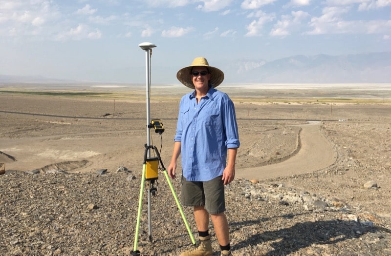
Steve Bacon, M.S., P.G., C.E.G. is an associate research scientist of geomorphology with the Division of Earth and Ecosystem Sciences at the Desert Research Institute in Reno and a Ph.D. candidate at the University of Nevada, Reno. Steve specializes in geology, paleoclimate, and landscape evolution, and has been a member of the DRI community since 2005. He is a licensed geologist and certified engineering geologist in California. He is also originally from southern California, and holds a bachelor’s degree in geology and a master’s degree in environmental systems – geology from Humboldt State University. In his free time, Steve enjoys skiing and camping with his family.


DRI: What do you do here at DRI?

Bacon: I work in engineering geology, geomorphology, and geologic hazards, which are fields focused on understanding  why landforms and landscapes look the way that they do and how they can potentially pose a hazard. I’m currently finishing up my pursuit for a Ph.D. in hydrology, focusing on paleoclimate modeling of Owens Lake in central California. Outside of my Ph.D. research, I work on U.S. Navy projects at China Lake through DRI’s Naval Earth Science Engineering Program (NESEP) , doing engineering geology and geomorphology. I also commonly work on Department of Energy (DOE) projects to assess the hazards related to surface erosion for DOE facilities in the western US, as well as on a National Institute of Health (NIH) project characterizing the spatial distribution of naturally occurring mineral fibers across northern Nevada.

Steve Bacon samples sediments along the bank of the Snake River in Idaho.

DRI: Can you tell us about your research at Owens Lake?

Bacon: Yes, I’ve been working to identify past precipitation changes in the Owens River watershed, in the southern Sierra Nevada mountains – so looking at how wet and how dry the environment in that area has been over many thousands of years. I’ve developed a lake-level record of Owens Lake going back 50,000 years. To do that, I’ve been dating shoreline deposits using radiocarbon and luminescence age dating techniques, and integrating lake sediment core records to produce a continuous lake-level record.

All of the precipitation and snowmelt from the watershed ultimately goes to the lake, so when the lake fills up, that’s a function of how much precipitation has occurred. So, using the continuous lake-level record, I’m doing watershed and lake hydrologic modeling to learn about changes in prehistoric precipitation levels that occurred over the last 12,000 years.

DRI: How will this information be used?

Bacon: Ultimately, it can be used to understand past atmospheric circulation patterns, like, where the jet stream was at different periods of time. For example, if it was dry in the southern Sierras, chances are the jet stream was further to the north. And when there were periods where it was relatively wet, the jet stream was further south. Atmospheric modelers can use that information to refine their models of the past.

This information can also help us to understand the future, to better understand climate change. To understand what potentially can happen in the future, we rely on the past; that’s one main reason why you study the past.

View from Steve Bacon’s field camp during a research expedition in the southern Owens Valley. Owens Lake and the Sierra Nevada mountains are in the distance.

DRI: How did you become interested in this particular research question?

Bacon: I love the east side of the Sierra Nevada. I always have, ever since I was a kid and we’d drive up to Mammoth or go camping out in Death Valley and Panamint Valley. I had an opportunity as a grad student to investigate the Owens Valley fault, which last ruptured in 1872 and produced the third largest earthquake in California. We trenched that fault to characterize the earthquake history, but to understand the earthquake history, we had to characterize the lake-level history, because the fault broke up the shoreline deposits left by the lake. So that’s when I started putting together the lake-level history of Owens Lake, as part of my master’s thesis at Humboldt State University. I’ve been working on this problem for 21 years.

DRI: What do you like about studying the ancient history of places like Owens Lake?

Bacon: It’s like a scavenger hunt. You’re looking around for clues to solve a puzzle. It’s a big geologic puzzle. We go four-wheel-drive around in the desert, or hike with a shovel, digging, cleaning off geologic exposures on different landforms, such as riverbanks and alluvial fans, just finding clues. Geologic clues. It’s fun. I like it. That’s why I do it, I guess.

Steve Bacon samples sediments along the bank of the Snake River in Idaho.

For more information on Steve Bacon and his work, please visit his directory page.