DRI’s Anne Heggli is partnering with the National Weather Service to understand flood risk from rain-on-snow storms in real-time, protecting communities and enabling water conservation throughout Nevada and California
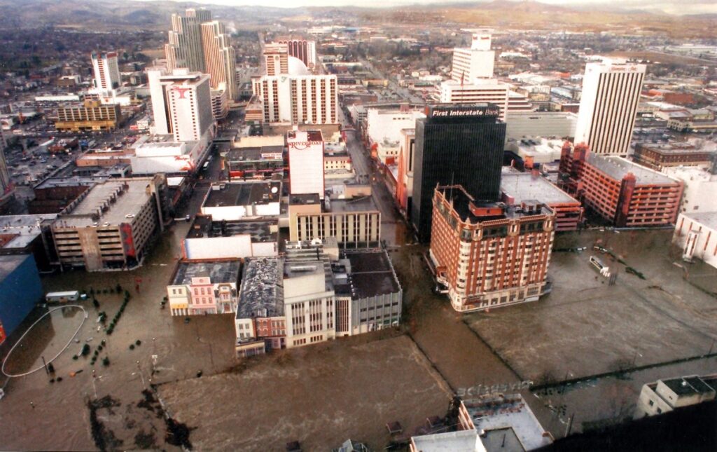
At the dawn of the new year in 1997, the Truckee River transformed. The winter season had thus far been great for snow, but when a subtropical storm from near the Hawaiian Islands rolled in, it carried with it unseasonably warm rain. The warm rainfall combined with snowmelt to swell the rivers, with the Truckee burying much of downtown Reno under water. Two people were killed amidst the nearly $1 billion disaster, and it wasn’t the first nor the last time that warm rains triggered severe flooding in the area.
These types of storms, called “rain-on-snow” storms, can produce river flows 50-80% higher than typical spring snowmelt. Nevada cities nestled against the dramatic peaks of the Sierra Nevada mountains are at particularly high risk from these storms: Reno and Carson City have records of flooding linked to these storms as early as 1862 and as recent as 2017. Despite the repeated challenge, predicting when these storms will occur and the risk of flooding remains challenging for scientists. DRI’s Anne Heggli, Ph.D., is on a mission to change that.
Heggli’s focus on rain-on-snow began early in her Ph.D. studies after she was approached by a water manager who told her that when it came to these warm storms, they felt like they were flying blind. “They had no idea how the snowpack was going to respond,” Heggli said.
Understanding how to predict when flooding will or won’t occur isn’t just important for public safety, but for water conservation as well. This is because water managers will remove water from reservoirs when flooding is expected, releasing it downstream to make room for the incoming flows. When water managers expect a flood that never arrives, the released water isn’t replenished, leaving less available for communities to draw from in the long dry season ahead. This is especially problematic for Nevada, the driest state in the nation.
With all this in mind, Heggli had the focus of her doctoral dissertation: to identify the weather and snowpack conditions that lead to flooding during rain-on-snow storms.
Advancing Scientific Understanding of Rain-on-Snow Storms
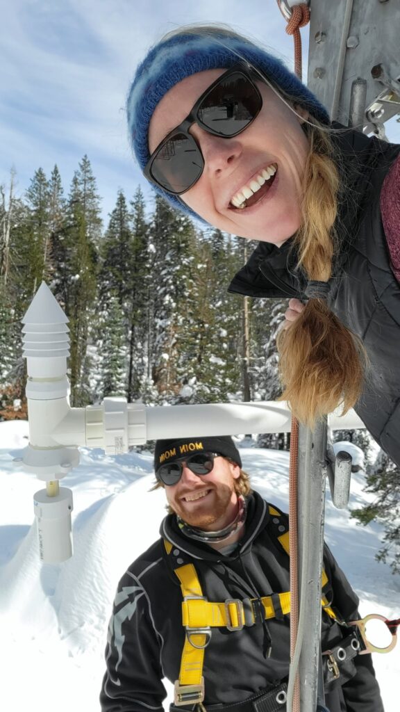
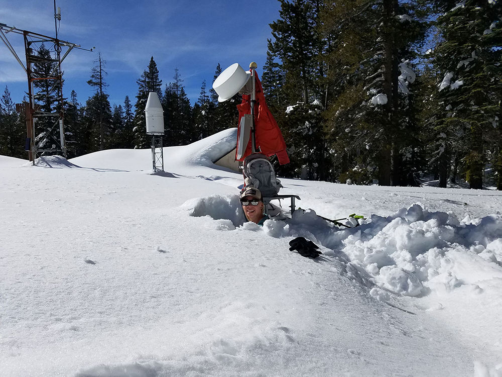
Heggli’s idea centered on using the existing Snow Telemetry (SNOTEL) Network to monitor real-time conditions in the mountains. This network has more than 800 automated weather stations scattered throughout high-elevation mountains in the Western U.S. Each station monitors the snowpack, precipitation, temperature, and soil conditions in order to help forecast water supply, as mountain snowpacks serve as some of the most critical water reservoirs in this part of the world.
Each of these stations, Heggli thought, had untapped potential. The measurements taken were being used on a daily timescale, but they were actually collecting hourly data, and it was this information that could help forecast potential floods.
“We really use the daily data, but the hourly data has not been applied,” Heggli said. “And I felt like there was a great opportunity to analyze it to shave away at some of the uncertainty about how the snowpack responds to rain and help inform the people who are managing our water in the Sierra Nevada.”
The SNOTEL stations in the Sierra Nevada mountains have included soil moisture sensors since 2006, which Heggli believed could provide insight into how the snowpack is contributing to runoff.
“When a rain-on-snow event occurs and the rainfall makes its way through the snowpack, there are these really prominent signals in the soil moisture data, so it’s a way to actually verify if the snowpack is releasing rainwater or snowmelt,” she says.
“The soil moisture data is key for my research because I can identify when the snowpack is releasing water, and then look at the snow density, air temperature, and precipitation,” she continued. “That way I can identify the patterns that are present every time the soil moisture has these really dramatic responses to find the ingredients that produce more impactful runoff rain-on-snow events.”
Anne’s work is helping fill gaps in what scientists know about rain-on-snow storms, such as where the soil moisture is coming from: rainfall, melting snow, or some combination of the two?
“It’s really about trying to tease out whether the runoff during rain-on-snow events comes from melting snow, or is it just rainfall and increased runoff efficiency?” she says. “What exactly is producing the runoff and why is it so hazardous? What are the ingredients of a perfect storm for those major rain-on-snow flood events?”
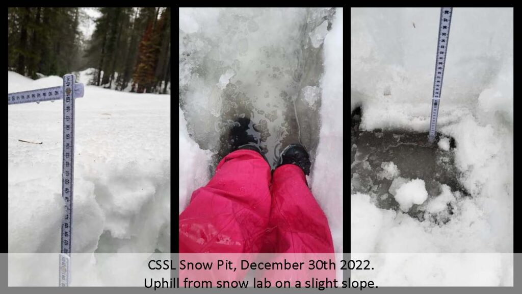
To help answer these questions, Heggli would head to the Central Sierra Snow Lab during storms. Here, she could dig snow pits that allowed her to see how water was flowing through the snowpack. During one visit, she measured 9cm of water at the base that grew to 13cm by the time she was leaving.
“It just really shows that the water is not able to move through the soil anymore and enter the streams that way — it’s now making its way over the surface,” she says. “And that is something that can really cause a lot of flooding, because it just moves so much quicker.”
“Anne’s work investigating rain-on-snow events is an exciting application of SNOTEL data,” said Jeff Anderson, Nevada Water Supply Specialist with the Natural Resources Conservation Service (NRCS). “The SNOTEL weather station network exists so the NRCS can forecast seasonal runoff in the western United States. To accomplish this goal, the NRCS relies on quality-checked daily data from the SNOTEL network.”
“Rain-on-snow events have produced our region’s most impactful floods,” he continued. “Anne methodically quality checks and integrates hourly SNOTEL data from a variety of sensors to predict when conditions could result in flooding. This is an important operational advancement in flood prediction, and it is exciting to see how NRCS SNOTEL data can be applied in new ways to benefit the public.”
Partnerships That Produce Actionable Science
Heggli’s work is notable not only for the scientific advancements, but also for how she has approached it. She partnered with the National Weather Service early on to ensure she was developing a useful tool for predicting rain-on-snow to help decision makers and emergency managers on the ground. With funding from UCAR through an educational partnership program called COMET that promotes university partnerships with NWS offices, she worked with hydrologist Tim Bardsley to co-develop a decision support tool that his own office would ultimately be using to monitor flood risk.
This initial funding was key, Heggli says, to establishing a productive working relationship that focused on producing research for the stakeholders.
“It was really this grant that allowed me to have that relationship with Tim to get the feedback that I needed to get this thing going in the right direction from the beginning,” Heggli says. “It’s been successful because it allowed me to build off the partnership with additional stakeholder partners like the Central Sierra Snow Lab and the Nevada Department of Transportation.”
Heggli emphasizes how unusual this type of grant funding can be, as most grants aren’t designed in a way that promotes close working relationships with stakeholders, allowing the research product to realign with stakeholder needs.
“Anne’s work has broadened our understanding of rain on snow, and just how rapidly rain can move through even deep and cold snowpacks to impact soil moisture, stream response and flood risk,” Bardsley says. “The tools Anne has developed help us at NWS Reno and the California Nevada River Forecast Center (CNRFC) quickly visualize near real-time data to highlight areas where rain is likely moving through the snowpack. This can help us better understand where and when our models are performing well, or not so well.”
The result is a tool that produces a map with a color-coded risk scale showing the potential for flooding in real time. For now, the tool is shared with Heggli’s partners at the NWS and NDOT so that they can make decisions about how to communicate flood risk to the public and water managers, and prepare emergency resources.
“They’re the ones that have to respond to flooding and help the communities out,” she says.
The map currently covers California and Nevada, but Heggli plans to expand it to include all of the SNOTEL stations across the Western U.S. She also has plans to make the tool publicly accessible and interactive through an online portal with DRI’s Western Regional Climate Center. A second COMET grant is helping develop the tool to integrate probabilistic forecast information to increase the lead time for flooding predictions.
“Right now, the tool is showing what’s happening on the mountain as it’s happening,” she says. “But if we can start to bring in probabilistic forecast information, we can see the spread of rainfall and air temperature at the different stations, and then start to communicate ‘Okay, we have an 80% chance that rain-on-snow runoff will happen at these lower elevations and a 20% chance at the mid elevations.’ It will help shave off uncertainty and forecast what might happen a few days out, which will help optimize water releases in reservoirs without increasing flood risk.”
Heggli emphasizes that this tool is the only real way that scientists can get information about flooding potential during storms, because satellite data doesn’t work with cloud cover and predictive models often omit outlier events — “but in the Sierra Nevada, those outliers are the events that impact us the most,” she says.
###
Note: Research featured in this article made possible through funding provided by:
University Corporation for Atmospheric Research COMET Outreach Program grant # MV1JFXA4S621 and Nevada Department of Transportation grant #P296-22-803
More information:
Read Anne’s Q&A about rain-on-snow events here: https://www.dri.edu/understanding-rain-on-snow-events-with-anne-heggli/
Watch this video from her presentation at DRI’s public science seminar series, Science Distilled.