The Sierra Nevada Mountain range, as of March 2023, contains a snowpack with more than 200% of an average year’s snowfall. Water managers across California and Nevada, states that rely on the snowpack as the region’s largest supply of fresh water, are celebrating what this means for alleviating some of the worst impacts of a widespread and ongoing drought. But with snowfall occurring at low elevations in unusual places, the possibility for warm atmospheric rivers to cause flooding increases. These storms, called rain-on-snow events, are the focus of DRI’s Anne Heggli, who is studying ways to improve our ability to forecast and prepare for these potentially hazardous storms.
Under the guidance of DRI’s Ben Hatchett, Ph.D., Heggli is working with the Nevada Department of Transportation and the National Weather Service in Reno to build better forecasting tools for rain-on-snow events, which will improve safety alerts and storm preparation across the state. DRI sat down with Heggli to learn more about her work, when rain-on-snow events are the most problematic, and why snowpacks don’t simply absorb rainfall like a sponge.
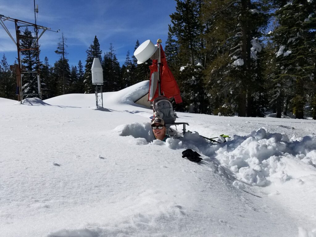
Above: Anne Heggli inside of a snowpit at the Central Sierra Snow Lab.
Credit: Anne Heggli/DRI.
DRI: Your Ph.D. work focuses on rain-on-snow events, can you tell us more about that?
Heggli: My Ph.D. work is focused on leveraging existing monitoring networks to try to find ways that we can maximize the investment that we’ve already made to learn about patterns with our snowpack to further our understanding of rain-on-snow processes, and to help inform decision makers on what exactly is happening in the mountains, hour by hour as these rain-on-snow events take place.
I got started with this because a water manager for a hydropower company in California told me that ahead of these atmospheric rivers, she felt like they were flying blind. They had no idea how the snowpack was going to respond.
DRI: And how are you doing that?
Heggli: The western U.S. has this great snow telemetry monitoring network, called the SNOTEL network, that’s run by USDA Natural Resource Conservation Service. All the stations collect hourly data for air temperature, precipitation, snow depth, snow water equivalent, soil moisture and soil temperature.
We really use the daily data, but the hourly data has not been applied. And I felt like that was a great opportunity to analyze this data to shave away at some of the uncertainty and help inform the people who are managing our water in the Sierra Nevada.
This data is especially important for the warmer atmospheric rivers that move through and put rain up over the crest of the mountains. It’s a way for us to understand what’s really happening in the deeper snowpack and what percentage of the watershed is actually contributing to runoff. The benefit of the SNOTEL network is the soil moisture sensors. In the Sierra Nevada, those have been installed since 2006, so there’s quite a lengthy record of soil moisture data there. And when a rain-on-snow event occurs and the rainfall makes its way through the snowpack, there are these really prominent signals in the soil moisture data, so it’s a way to actually verify if the snowpack is releasing rainwater or snowmelt.
The soil moisture data is key for my research because I can identify when the snowpack is releasing water, and then look at the snow density, air temperature, and precipitation. That way I can identify the patterns that are present every time the soil moisture has these really dramatic responses to find the ingredients that produce more impactful runoff rain-on-snow events.
DRI: Is soil moisture a measure of melted snow, or is it rainfall that’s passing through the snowpack to the soil?
Heggli: That’s one of the things that is kind of unknown. There’s been an assumption that the snowpack is melting. But some of the research in my first paper shows that during these rain on snow events, snow melt is not the primary driver of runoff in deeper snowpacks. Shallow snow will be obliterated, but in the deep snowpack, sometimes that snow will actually absorb part of that rainfall. But essentially, except for very exceptional events — like the 1997 flood event and February 2017 in the Sierras — snow melt typically is not part of the runoff process in the deeper snowpacks. However, in the shallower snow at lower elevations, it can begin to melt and then that increases the amount of water available to runoff into the streams.
It’s really about trying to tease out whether the runoff during rain-on-snow events comes from melting snow, or is it just rainfall and increased runoff efficiency? What exactly is producing the runoff and why is it so hazardous? What are the ingredients of a perfect storm for those major rain-on-snow flood events?
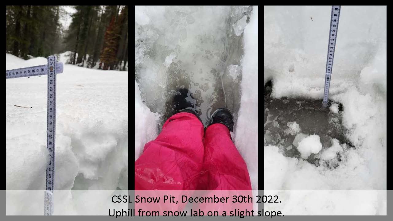
Heggli’s snowpit at the Central Sierra Snow Lab during the December 2022 storm.
Credit: Anne Heggli/DRI
DRI: Why can rain-on-snow events be a problem?
Heggli: Well, it’s highly uncertain at times. There are times, like in 1997, where we knew that this very warm storm was coming in with a lot of moisture and precipitation and very high-elevation freezing levels. Sometimes when the atmospheric rivers make landfall, they’ll push against the Sierra Nevada and they’ll start to lift and at some elevation that rain is going to transition to snow. Understanding and forecasting the elevation that rain turns to snow is extremely difficult. And it can really change the amount of water that is being produced as runoff. In some storms, maybe 50% of the entire basin is contributing to runoff because of where the snow level is. But in other times, like in the 1997 event, you now have 100% of the basin actually contributing to runoff, and the more problematic floods have happened when we get a warmer atmospheric river just after a cold and low elevation snow event — just like something we just had — where there’s snow down to 2,000 or 3000 feet. When you take that shallow snow, and then you have rain come over it, it melts really quickly. Even if you only have three inches of snow at that lower elevation, the rain plus that three inches integrated over an entire area really increases the amount of runoff that’s available. My work is about trying to understand those vulnerabilities and when the situational awareness should be increased.
Another example was in 2017, when the Sierras had a rain-on-snow event in January that primed the snowpack and the soils, and then in February we had another atmospheric river rain-on-snow event, and that caused quite a bit of flooding. So, I’m trying to understand the evolution of how the first rain-on-snow event might impact the soils and the snowpack to kind of prime the system.
We can monitor these systems to understand if we have the capacity to take on some of that rain-on-snow, or if there are things like low elevation snow or prior rain-on-snow events that should really be alerting water managers. That way they can prepare by routing water to give it the most beneficial use up in the mountains or make sure they’re releasing some from reservoirs well ahead of the event so that there is the capacity to take on floods. In the worst-case scenarios, identifying the vulnerabilities early on can help inform emergency managers to decide if, or when, to start sending out sandbags and prepping for potentially failed levee systems well in advance of the impact.
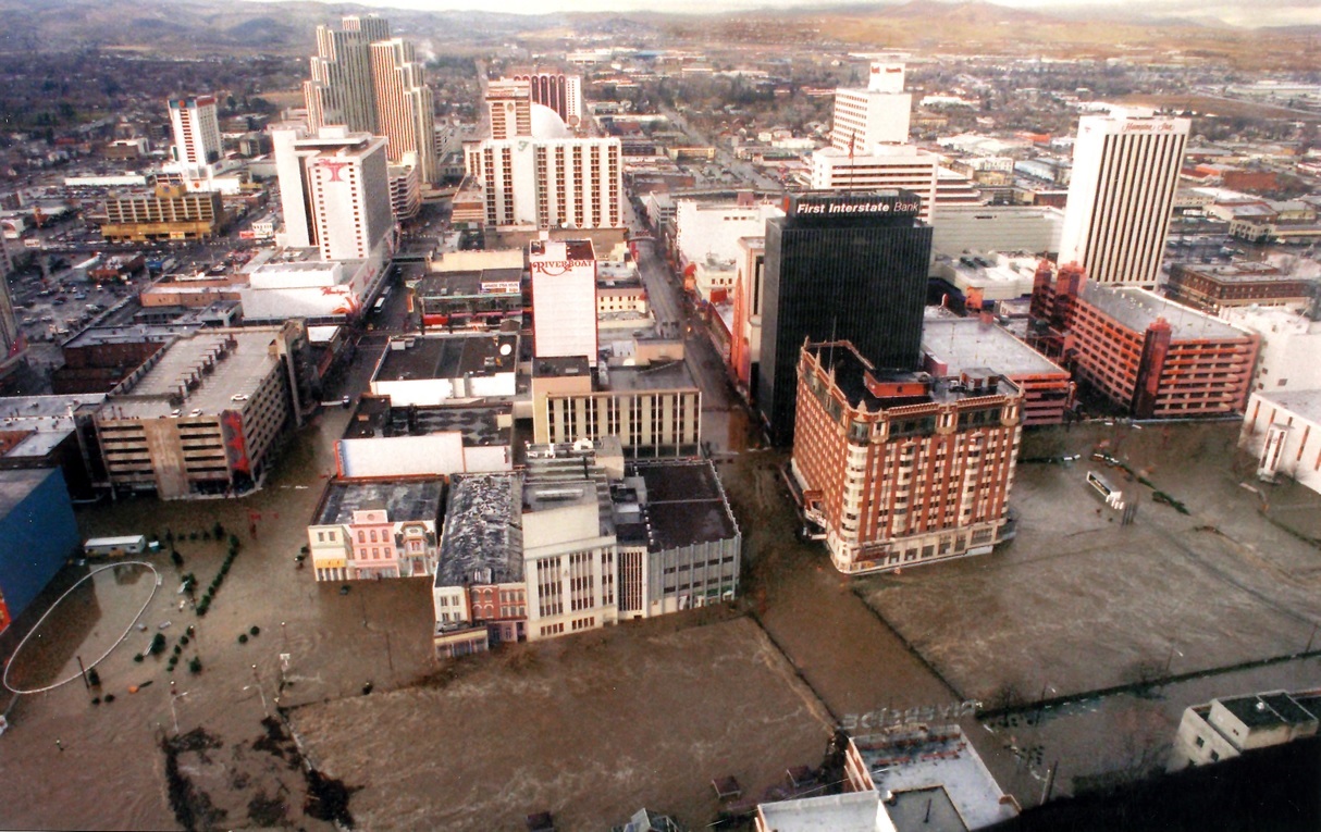
Flooding in downtown Reno after a 1997 rain-on-snow event.
Credit: Nevadafloods.org
DRI: So, one thing that water managers can do, if they have enough warning that a rain-on-snow event might be imminent, is to release water from the reservoirs to make room for the flooding event?
Heggli: Yeah, a lot of that’s controlled by the Army Corps of Engineers, and there are strict rules for operating reservoir levels during flood season. But for hydropower companies that operate very complex networks up in the mountains, they can move water between their reservoirs. Depending on the capacity of one reservoir adjacent to another, they might be able to move water between them to keep it up in the mountains. That way, we have access to it in the summertime when it’s most needed. That’s why giving them information to prepare for storms can hopefully help us save water for the most beneficial use, so they don’t have to rely solely on releasing water downstream. Of course, that’s if there is the capacity in those reservoirs to actually take on a little bit more.
DRI: How common are rain-on-snow events in California and Nevada?
Heggli: They’re relatively common. One rain-on-snow event a year is pretty common, and we have years where we don’t get any. But we’ve also had years where we get as many as five rain-on-snow events. Everything in the West is highly variable but it’s definitely not uncommon and this is by no means something new – there are photos from 1955 of downtown Reno being flooded very similarly to 1997. So, it’s something that has always been a problem in this region.
What is new is that we are now confronting a changing climate where snow levels are rising, and it’s projected that more precipitation is going to be falling as rain than snow. This means we’re kind of approaching this period of peak rain-on-snow events while the atmosphere is warming, because more rain than snow is falling but we are still getting snow for the rain to fall on. So, it’s something that we very much need to be paying attention to and it’s going to continue to be — I don’t want to say a problem, it can cause problems — but it is definitely something that we need to make sure we’re adapting to and informing our emergency managers and water managers about so they can make the best decisions with our resources and infrastructure available.
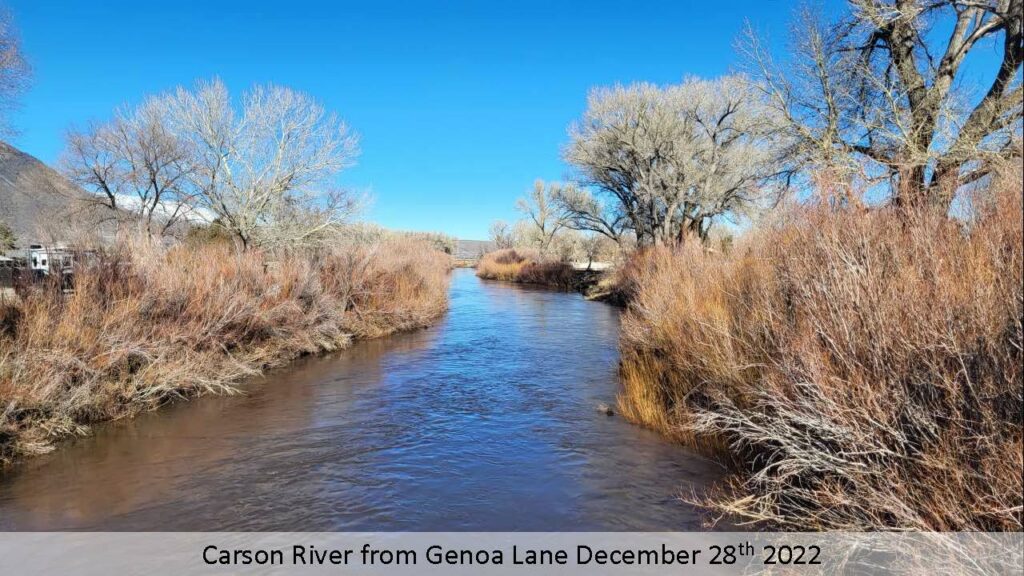
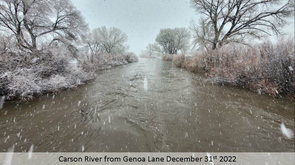
Above: Two photos contrasting the Carson River’s flow before and after a December 2022 rain-on-snow event.
Credit: Anne Heggli/DRI.
DRI: There’s been some chatter amongst meteorologists right now about the possibility for rain-on-snow events later this week (around March 10, 2023). What are your thoughts about the likelihood of this event right now and where do you see it having an impact and at what scale?
Heggli: We have seen signals for a potential warm atmospheric river (AR) and over the last couple of days the models have been converging in agreement that a lower magnitude AR is approaching. The exact location of landfall and the freezing level in the atmosphere is still uncertain at this point. However, even a weak yet warm atmospheric river, combined with all the low elevation snow, could still be very impactful. The low elevation snow, high soil moisture content, and higher river levels, which we currently have, tick the ingredients boxes for increased potential impacts from a warmer atmospheric river. It’s something to keep an eye on, but the predictions don’t yet show something huge like 1997 — there is something coming but it’s still quite uncertain how it will evolve.
DRI: Is there anything else you think is important?
Heggli: I think it’s important to communicate that the snowpack isn’t a sponge — I think there’s a really common misconception that, “Oh, rainwater moves in this uniform wetting front and just slowly makes its way down.” That’s not at all what happens during rain-on-snow events, especially higher intensity ones. The rain will hit the surface and then it looks for the path of least resistance. It uses capillary attraction to find ways to work through the snowpack, and it’ll form what they call flow fingers, or preferential flow paths. It’s like the way that you see icicles line up, the water drips in specific places. It’s something similar to that where water will find the path of least resistance and warm the snow just enough there to make its way through, which makes it easier for all the other rainwater to follow. So, it doesn’t actually need to warm the snowpack evenly to be able to progress. It’ll find these little paths, and it just basically punches its way through the snowpack.
Part of the concern with rain-on-snow events is that we have higher runoff efficiencies because the rain can punch through the snowpack and make its way to the soil and then run off. And if there’s so much rain that’s coming through that the soils can’t take it on, then that rainwater actually starts to move through the base of the snowpack. I posted a photo from December 30 when I was up at the Central Sierra snow lab during the rain-on-snow event, digging a snow pit in the rain. When I got there, there was nine centimeters of standing water at the base of the snowpack. By the time I left there was 13 centimeters of standing water at the base. So, it just really shows that the water is not able to move through the soil anymore and enter the streams that way — it’s now making its way over the surface. And that is something that can really cause a lot of flooding, because it just moves so much quicker.
Unfortunately, a lot of the work on this seems to have been forgotten and isn’t well integrated into our forecasting models. A lot of the existing models cannot handle preferential flow paths or lateral flow through the snowpack. I think this is because people aren’t out in the field making observations as much anymore, they’re relying heavily on computer simulations. These are helpful, but they also tend to remove outlier events, and in the Sierra Nevada those outliers are the events that impact us the most. You know, none of the work that I do matters until it actually matters, and then it matters a lot. We can have years where what I do is of no use to anybody. But years like this is when we really need additional information because there’s nowhere else to get information — we can’t get satellite data because of cloud cover. So, all that we have to understand what’s going on in the mountains are observational networks. That’s part of the reason that I thought, “we’ve got to use this data.”
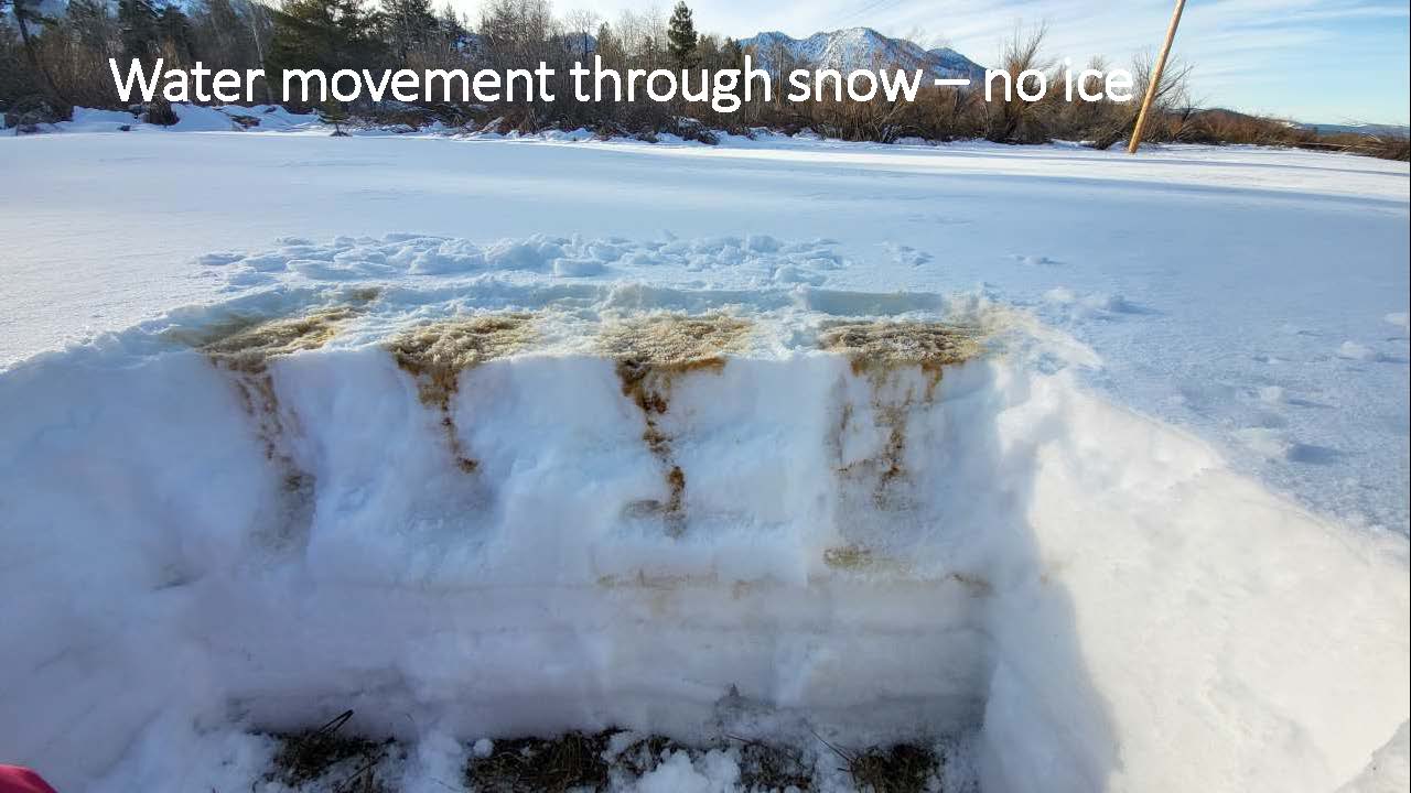
Heggli’s experiment using instant coffee to track the flow of water through the snowpack.
Credit: Anne Heggli/DRI.
DRI: So, you’re going out in these rain-on-snow events and digging down to the bottom of the snowpack to see what’s happening?
Heggli: Yeah. You can see from the snow surface the development of the preferential flow paths. To try to better understand these flow paths, sometimes I take instant coffee and put it in a spray bottle and spray the snowpack, and then go and dig it out. I can do different quantities of spray and then let it sit overnight and see how far those preferential flow paths progress — that way I can see the contrast of the coffee against the snow. I do that to try to better understand and observe and document what is really happening with the rain-on-snow and hope that some of these visuals help get the idea across that snow isn’t a sponge, and this is why rain on snow events are so difficult, but also interesting.
For more information on Anne and her research, watch this video from her presentation at DRI’s public science seminar series, Science Distilled.


