The project aims to revolutionize water and agricultural decision-making across the region.

India’s Ganges River is the life-giving force of the nation, supporting most of the country’s population and agriculture. Born from snowmelt in the towering peaks of the Himalaya Mountains, the river is under threat from extreme weather changes and increasing groundwater extraction to support the nation’s growing population. DRI’s Sayantan (Monty) Majumdar, Assistant Research Professor of Hydrologic Science and Remote Sensing, is joining forces with an international team of researchers to create a digital twin of the entire river basin that will support decision-makers as they work to protect this critical resource. Originally hailing from the river’s fertile lands, Dr. Majumdar is now based on DRI’s Reno campus, where he contributes to a wide range of research on water management issues in the Western U.S. As a no-cost Co-Principal Investigator (similar to a volunteer consultant role) on the project, he is excited to contribute the knowledge and models developed by teams like the OpenET project and apply them to India in order to expand their reach and test their efficacy in different climates.
“The Ganges Digital Twin Initiative aims to revolutionize water and agricultural decision-making across the basin by integrating advanced hydrologic and hydrodynamic models, artificial intelligence, satellite remote sensing, and data assimilation into a unified digital framework,” said Dr. Gaurav Talukdar, Assistant Professor in the Department of Civil Engineering at the Indian Institute of Technology Delhi (IIT Delhi), one of the project’s lead researchers.
The project will generate a range of useful products, including a comprehensive Water Cycle Atlas, high-resolution agricultural productivity maps, and precipitation whiplash vulnerability zones to support climate-resilient planning. In addition to developing a retrospective and future outlook of the basin’s water cycle, the initiative will create a sector-specific atlas focused on agriculture and interactive dashboards for real-time data visualization and query. Building on the hydroclimatic stress zones identified through this effort, Dr. Majumdar will lead a focused investigation into groundwater dynamics in vulnerable agricultural regions, strengthening understanding of the spatial and temporal availability and use of groundwater across the Ganges River Basin. Over the next three years, this collaboration with institutes including IIT Delhi, NASA Goddard Space Flight Center, the Netherland’s Utrecht University, and Japan’s Hokkaido University is expected to deliver India’s first truly integrated river-basin digital twin for the Ganges, directly supporting climate-resilient water management, sustainable agriculture, and groundwater security for millions of people.
Below is a brief Q&A with Dr. Majumdar about the project.
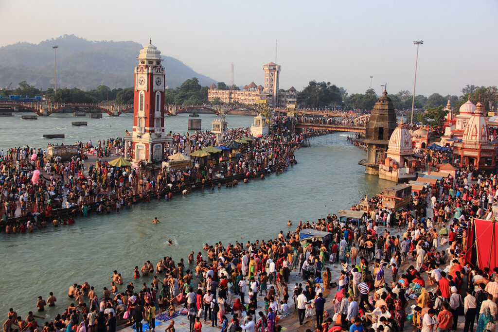
The Ganges River Basin supports most of India’s agriculture and human population.
DRI: Tell us about the importance of this project.
Majumdar: We’re building a digital twin of the Ganges River in India — the entire basin, more than 800,000 square kilometers. It’s a very sacred river to the people of India that supports the majority of the nation’s population. It’s also a very fertile area where more than half of the country’s agriculture is centered. The river is also experiencing changes due to extreme weather, with shifts from extremely dry seasons to extremely wet seasons. There was a study in 2009 that used a NASA satellite and found significant groundwater depletion in northwestern India – it really brought the issue to a lot of people’s attention. For these reasons, it’s extremely important we know what’s going on in this basin.
DRI: How did you get involved in the project?
Majumdar: I met one of the co-lead researchers, Dr. Gaurav Talukdar of IIT Delhi, at the AGU Fall Meeting 2024 in Washington, D.C., and we were inspired to collaborate. Earlier this year in February, I presented a talk on satellite remote sensing of irrigation water use at IIT Delhi, which is the lead organization on the project, and built more connections there. Dr. Talukdar (Co-PI, Assistant Professor) and Dr. Manabendra Saharia (PI, Associate Professor) invited me to join the proposal in May, and we got funded by the National Mission for Clean Ganga (Ganges), which is a big initiative in India. The total funding is about $370,000 (₹33M) for three years, which will support developing open-source tools for the region. This is critical because researchers in India just don’t have access to the same kind of publicly accessible data that we have here in the U.S. By building an open-source model, anyone will be able to access the project’s work, even after the project concludes. The end goal is to better understand what’s happening in the basin that supports so many people.
DRI: Tell us about your role on the project.
Majumdar: I was selected for the project because of my previous work modeling groundwater pumping and integrating machine learning approaches. I recently helped develop a method with Colorado State University to better understand how much precipitation is actually residing in the crop root zone and used for irrigation in the Western U.S. We call that “effective precipitation”, and using that information, we can estimate irrigation water use by subtracting it from total evapotranspiration. So, we’ll do some initial tests like that for this project — using transfer learning and applying that model that was developed in the Western U.S., tweaking it, and then applying it to the Ganges River Basin.
We’ll also use the public data repositories that are available for the region and apply knowledge developed by our team at OpenET. The source codes for most of our OpenET models are open, so the team will run some of those, compare with other open evapotranspiration datasets, and use the effective precipitation data to get some preliminary estimates of groundwater pumping. It’s similar to the approach we use in the Western U.S., but we’ll need to be more careful about missing data, because satellites can’t see the ground surface due to clouds during much of India’s rainy season.
DRI: You’re applying lessons learned from working on water issues in the Western U.S. to a completely different part of the world. What challenges do you anticipate encountering?
Majumdar: The driving force behind this project is to address a vast gap in available data for the region – we don’t have nearly as many measurements for things like streamflow and groundwater withdrawal for India as we have here in the Western U.S. All across the Global South, in situ measurements are very limited, and that’s where remote sensing plays a huge role. That’s why the idea is to develop a digital twin – a replica of the entire system – of the Ganges River Basin, to see what’s going on with the entire water cycle: precipitation, groundwater extraction and recharge, irrigation, streamflow, and how all of these factors are impacted by climate.
DRI: Will the project be driven by remote sensing?
Majumdar: We’re integrating both physical and remote sensing based models with AI framework.
DRI: When are you hoping to have this project completed?
Majumdar: It’s a three-year project that just started, and we’re hoping to have some initial results sometime next year.
DRI: What is the most exciting thing about this project for you?
Majumdar: I think the most exciting part is that I get to apply the methods I developed for the U.S. and see how they actually work in other regions. We always talk about method transferability and how our work can be useful in regions around the world, and this is where I think we can actually test whether that claim holds true – that’s exciting to me.
——————————-
More information and related research:
IIT Delhi to Build India’s First Digital Twin of Ganga River Basin: Times of India
Hasan, M. F., Smith, R. G., Majumdar, S., Huntington, J. L., Alves Meira Neto, A., & Minor, B. A. (2025). Satellite data and physics-constrained machine learning for estimating effective precipitation in the Western United States and application for monitoring groundwater irrigation. Agricultural Water Management, 319, 109821. https://doi.org/10.1016/j.agwat.2025.109821
Ott, T. J., Majumdar, S., Huntington, J. L., Pearson, C., Bromley, M., Minor, B. A., ReVelle, P., Morton, C. G., Sueki, S., Beamer, J. P., & Jasoni, R. L. (2024). Toward field-scale groundwater pumping and improved groundwater management using remote sensing and climate data. Agricultural Water Management, 302, 109000. https://doi.org/10.1016/j.agwat.2024.109000
Majumdar, S., Smith, R. G., Hasan, M. F., Wilson, J. L., White, V. E., Bristow, E. L., Rigby, J. R., Kress, W. H., & Painter, J. A. (2024). Improving crop-specific groundwater use estimation in the Mississippi Alluvial Plain: Implications for integrated remote sensing and machine learning approaches in data-scarce regions. Journal of Hydrology: Regional Studies, 52, 101674. https://doi.org/10.1016/j.ejrh.2024.101674