Scaling Environmental Processes in Heterogeneous Arid Soils (SEPHAS)
SEPHAS Lysimeters
What is a lysimeter?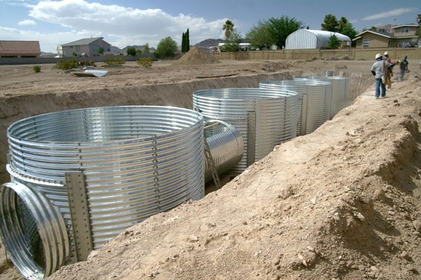
A lysimeter enables researchers to study and understand the natural environment by capturing the natural water gain and loss in a soil column under controlled conditions such as infiltration, runoff, and evapotranspiration.
Lysimeters are buried containers of soil equipped with a weighing device and drainage system to measure evapotranspiration and percolation. Each of the lysimeters represent existing soil, vegetation, and climatic conditions in order to improve the accuracy of measurements of the actual physical processes.
About the SEPHAS Lysimeter Facility
 The SEPHAS lysimeters are cylindrical containers 7.4 ft in diameter and 9.8 ft high and contains 423.8 ft3 (12 m3) of re-packed Arizo sandy loam collected from Eldorado Valley and sits on a separate weighing scale. Each lysimeter weighs 62,000 lbs (28,000 kg) and the accuracy of the scale is ±14.4 oz 0.004” of water (±408 g or 0.10 mm of water).
When the soil was installed, four conservative tracers were applied uniformly at four depths from 0.49-1.8 ft (0.15-0.55 m). Each lysimeter is instrumented with 153 sensors installed at 15 different depths from 0 to 9.5 ft (250 cm). The sensors include 17 different instruments for measuring soil, water, gas, and temperature profiles. These data loggers can be accessed remotely so investigators can monitor individual sensors and weather systems as needed.
Upscaling environmental processes is critical for research in environmental engineering, hydrology, and biogeosciences. The SEPHAS lysimeter facility allows scientific experiment to bridge the gap between laboratory and field scale to improve our understanding of water conservation and management, ground and surface water supply, groundwater recharge, flood control, and climate change.
Capabilities
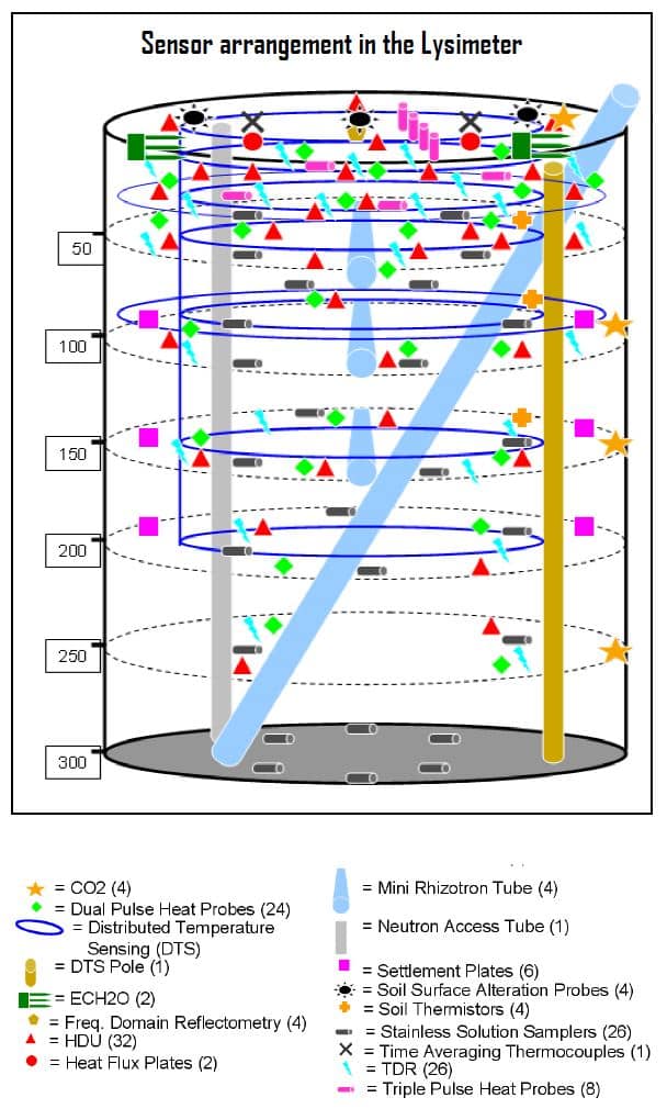 From inside a lysimeter, data such as water content, matric potential, temperature, thermal properties, electrical conductivity, soil settlement, and erosion are measured. Ports for pore water sampling and access tubes for digital imaging of soil cross sections are installed. As a special feature, a distributed temperature sensing system is also installed to obtain horizontal temperature profiles at six depths as well as a continuous vertical temperature profile.
Soil and weather measurements are made at 15 to 30 minute intervals using more than 150 sensors. These data include parameters such as moisture content, air and soil temperature, and precipitation. Researchers measure how moisture and temperature of the soil change during and between storm events. This allows to study how much storm water is stored in the soil during dry periods and available for plant growth.
Meteorological and atmospheric conditions are monitored using a fully equipped eddy-covariance meteorological tower measuring air temperature, relative humidity, precipitation, solar radiation, and wind speed and direction.
The data is collected and can be viewed as maps and graphics in real-time at sephas-data.dri.edu .
CONTACT
Markus Berli, Ph.D.
Program Director
Markus.Berli@dri.edu
LAB LOCATION
Desert Research Institute
1500 Buchanan Blvd.
Boulder City, NV 89005
DIVISION
Hydrologic Sciences