Center for International Water and Sustainability
DRI-Liberia Capacity Building Program
CIWAS supported the Liberian government to help develop national water quality monitoring capacity. CIWAS hosted a training and capacity building workshop in Liberia on water quality monitoring to support the government in developing the nation’s water quality standards and to establish baseline water quality parameters. CIWAS also conducted field research in five counties. Working with staff from the Ministry of Health, CIWAS also sampled and completed field tests on water from approximately 50 wells. The samples were tested for chemical, physical, and bacteriological water quality parameters. Results were critical to help the Liberian government establish an initial understanding of chemical and bacteriological constituents in the nation’s groundwater.
CIWAS also supported UNICEF’s work to address gaps in WASH in healthcare facilities as part of a national response following the Ebola outbreak in the country. DRI was selected to partner with UNICEF to undertake the hydrogeological/geophysical investigations and surveys for the siting, drilling, and supervision of 50 boreholes in selected health care facilities across the country and some communities.”
BACKGROUND
A period of recovery and resiliency building was instituted following Liberia’s Ebola free declaration. UNICEF Liberia’s response addressed gaps in water, sanitation, and hygiene (WASH) in health facilities as well as in some communities identified during the Ebola response. The Desert Research Institute (DRI), part of the Nevada System of Higher Education, won a bid to implement hydrogeological/geophysical investigations and surveys for drilling and surveying 50 boreholes.
Project staff from DRI and our subcontractor, ProHydro, implemented the project. Several meetings were held with UNICEF Liberia, and the Liberia Ministries of Health and Public Works, Hydrological Services, and Liberia Geological Services. Team members also met with several non-governmental organizations (NGOs), including Living Water International and ZOA. Borehole data was also obtained from Living Water International and the Hydrogeological Services Department for initial assessment.
Key activities that have been undertaken so far include:
LITERATURE REVIEW AND DESK STUDIES
Much of the data and research on water resources and hydrogeology of Liberia has been lost due to the high degree of political instability within the country. The research and data was derived largely from several studies, as well as pre-war literature from the seventies and eighties. The available hydrogeological and meteorological data is still very scarce and there is a great need for more research (Elster et al. 2014). The literature included Liberia’s geology, hydrogeology, and soil study. All available hydrogeological, geological, and meteorological data was compiled. This report presented a summary of some of the most reliable and valuable resources, but the compiled database is far more exhaustive. A literature review of remote sensing techniques for groundwater in tropical areas was also completed. All data and information from this literature review was shared with UNICEF.
Liberia covers an area of approximately 111,370 km2 and is located in West Africa between the latitudes of 4 and 8 degrees. The temperature throughout the country ranges from 27-32 degrees Celsius during the day and 21-24 degrees Celsius at night. Highest temperatures are recorded from January to March and the lowest between August and September. Lower temperatures are largely caused by cloud cover (Golder Associates, 2012). Geographically, the country is divided into four zones; the coastal plains, the rolling hills, the plateau and tablelands and the northern highlands (UNEP, 2004).
The coastal plains follow the entire coastline (~579 km) and extend up to 65 km inland with a maximum altitude of 50 m. The coastal plain is characterized by coastal and riparian vegetation, river deposits, mangrove swamps, and lagoons. The next zone inland is the rolling hills, which constitutes the most favorable agricultural zone in the country. The rolling hills zone is made up of hills, valleys and rivers. To the southeast and southwest the rolling hills zone is covered in tropical rainforests. The plateau and tablelands are up to 300 m in elevation with mountain peaks reaching 610 m. At the widest point the zone is 129 km wide (between the Lofa and St. Paul Rivers). The highest points in Liberia are located in the northern highlands within Nimba and Lofa County (UNEP, 2004).
Hydrology
Prior to the civil war there were 47 meteorological stations in Liberia with rainfall statistics dating back to 1927. All of the meteorological stations were destroyed during the war and no new data has been recorded since (Golder associates, 2012).
Surface water is an abundant resource in Liberia, largely due to its climate and geography. Of Liberia’s 111,370 km2; 15,050 km2 is covered in water. Various large lakes and six major rivers comprise the majority of the surface hydrology of the country. The six major rivers are The Cavalla, Cestos, Lofa, St. John, Mano, and the Saint Paul River. The majority of the large drainage basins run perpendicular to the coastline (NE to SW) and eventually drain into the Atlantic Ocean (UNEP, 2004). Lake Piso is the largest lake; however, proximity to the coast and elevation create a tidal influence and thus the lake water is brackish. A generalized figure of Liberia’s topography and hydrology can be seen in Figure 1.
Precipitation in the northern regions of Liberia is strongly influenced by the West African Monsoon (WAM). During the wet season, humid air from the Atlantic Ocean blows over the continent causing high levels of precipitation, a phenomenon known as WAM. The wet season generally lasts May through October, during which many areas of coastal Liberia receive over 1000 mm of rainfall per month. During the winter or dry season (December-March), the winds generally reverse and Liberia receives the drier Harmattan winds from the Sahara Desert. Southern Liberia receives a steadier level of precipitation due to the fact that it lies closer to the equator and has a more equatorial climate (Van Straaten, 2002). It has been estimated that Liberia’s total annual renewable freshwater supply is approximately 300 km3 (Macdonald et al. 2012).
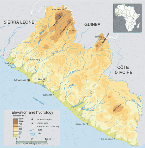
Figure 1: Generalized Map of Elevation and Hydrology of Liberia (UNEP, 2004)
Geology
Information on geology comes primarily from the United States Geological Society (USGS) reports, as well as several studies conducted by mining companies. The most comprehensive data set to date is the geological, geophysical, and mineral localities maps of Liberia digitally compiled by Wahl, 2007. These maps have been obtained and are the best representation of the known available geologic data for the country. Like the majority of the African continent, Liberia is underlain primarily by Precambrian crystalline basement rock. Liberia makes up part of the Guinean (Leo or man) shield of the West African craton. Precambrian (Archean and Proterozoic) crystalline rocks are the dominant rock type (~90% of the country) except for certain parts of the coastline where unconsolidated sediments and sedimentary rocks are found. Radiometric dating has defined three major age provinces that comprise the Precambrian basement rock in Liberia. The oldest unit is the Liberian age member, approximately 2,700 to 3200 Ma (Archean). The Eburnean age province was metamorphosed approximately 2150 Ma (Paleoproterozoic). The youngest member is the Pan-African age province, approximately 550 Ma (Neoproterozoic). The western two-thirds of Liberia is made up primarily of the Liberian age province, which contains the famous iron ore deposits of the bong range. The Liberian age province was affected by both the Leonian (3,500-2,900 MA) and Liberian (2,500 MA) orogenies. The southern/central third of the country is made up of the Eburnean age province and contains Birimian age greenstone belts. A narrow belt of Pan-African age rock runs adjacent to the coast, separated from the Liberian age province by a series of NWW-SEE trending faults, which make up the Todi shear zone. The Pan-African age rocks are comprised of metamorphic rocks metamorphosed to amphibolite grade, as well as granulite facies rocks most likely derived from older Archean rocks (Shluter, 2006). The majority of the sedimentary rocks found in Liberia are in close proximity to the coast adjacent to the Pan-African age rocks. The sedimentary sequence is made up of various Cenozoic coastal plain deposits, Devonian sandstones and cretaceous conglomerates.
The Todi shear zone extends from northern Liberia 300 km southeast, where it terminates. The series of faults known as the Todi shear zone in Liberia also continue 400 km north into Sierra Leone, where they separate the Kasila Group from Kenema Assemblage rocks. The boundary between the Eburnean and Liberian age provinces is not well defined (Shluter, 2006). Also present are several fault systems, which comprise various shear zones which run SW to NE throughout the country. Another striking geologic feature is the notable band of Jurassic diabase dikes which run NW-SE.
Several sedimentary deposits have been noted, particularly in the areas between Monrovia and Buchanan. The majority of sedimentary rocks are located near the coast, largely below 20 meters above sea level. In Liberia outcrops of sedimentary rocks are far less common than those of metamorphic and igneous rocks. The oldest known sedimentary unit is the Paynesville sandstone, which is a fine-grained Paleozoic sandstone. The next sedimentary unit in the sequence is the cretaceous Farmington River Formation made up of wacke and polymict conglomerate. The Edina Sandstone is next in sequence and is a well-sorted, coarse-grained sandstone from the tertiary. Unconsolidated quaternary sediments made up of sand, sandy clay, clay, and peat lie at the top of the sequence. Although several of the sedimentary units may be widespread, the majority of known outcrops tend to be near the coast by Monrovia (white, 1969). Two clastic sedimentary rock anomalies, known as the Gibi Mountain Formation have been recognized. They are basal conglomerate overlain by arkosic siltstones and sandstones which are overlain by shale. It has been suggested that the sediments have a glacial origin. Heavily forested hills overly the formation approximately 32 km NE of the Todi Sear zone. The formation is likely Neoproterozoic to Cambrian in age (Shluter, 2006).
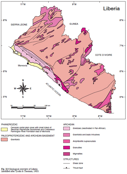
Figure 2: Generalized Geologic Map of Liberia (Schlutter, 2006)
Hydrogeology
The available hydrogeological data for the country of Liberia is scarce and there is a great need for more research. Very few peer-reviewed studies concerning the hydrogeology of Liberia have been published: however, these, along with nonacademic literature from mining companies and various agencies, have been collected and analyzed. Other peer-reviewed studies on the hydrogeology of crystalline basement rock terrain in West Africa have been compiled and reviewed, as they may be applicable. Borehole data has been obtained from UNICEF and Cranfield University. The Manual Drilling Feasibility Mapping of Favorable Zones study conducted by the Republic of Liberia, UNICEF, Enterprise Works, and Practica synthesizes much of the known hydrogeological data obtained from borehole drilling. The Manual Drilling study was based on fifteen documents, of which fourteen have been retrieved. The Liberia Waterpoint Atlas data set has also been downloaded and may prove useful.
As with meteorological data, very little hydrogeological research and data are available for Liberia. Due to the occurrence of Precambrian crystalline bedrock throughout the country, the hydrogeological setting tends to be complex and has led to high borehole failure rates in many water projects. Both surface hydrology and groundwater are often influenced by structural and weathering controls. Groundwater is generally associated with the saprolite and saprolite-fractured bedrock layer. The Saprolite is chemically weathered granitic/gnesisic rock that represents deep weathering. It forms in the lower zone of the soil profile. Saprolites are typical of flat regions with ancient bedrock and high precipitation. The weathered saprolite forms part of the weathered mantle and contributes to aquifer formation. Saprock-fractured rock is less chemically weathered, but highly fractured and also governs groundwater flow and storage. Elster et al, 2014, combine the terms saprock with fractured bedrock (fresh bedrock with deep structurally controlled fractures) as saprock-fractured bedrock. Several studies in Liberia and similar environments suggest a typical downward sequence of soil to laterite to saprolite to saprock- fractured bedrock and finally to unweathered fresh bedrock (fig 3). The greatest permeability is typically found at the base of the fractured rock zone, while the storage is greatest in the more weathered but lower permeability material above. The thickness of the weathered regolith (saprolite and saprock) and depth to bedrock have been found to impact the sustainability of the wells throughout the dry season.
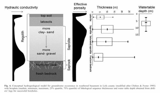
Figure 3: figure taken from Elster et al. 2014
Due to the lack of available borehole data, it is difficult to infer depths to the water table, and depths to fresh bedrock throughout the country. Nonetheless, several past reports which include borehole data have made initial estimates. In a 2011 report titled “An initial estimate of depth to groundwater across Africa,” The authors, Bonsor and Macdonald, estimate the water table depth to be approximately 7-25 m, and the saturated aquifer thickness to be less than 25 meters in Liberia. An independent 2014 study that only analyzed borehole data from Lofa County, Liberia examined depth to bedrock as control of mantle thickness. The study found that the depth to bedrock rarely exceeded 25 m and had an average depth of roughly 7 m, these values are in range with Macdonald’s estimates. Based on effective porosity and saturated aquifer thickness total groundwater storage has been estimated to be 86 km3 with a large range of 25-333 km3 (Macdonald et al 2012).
Remote Sensing DEMs
A 30-meter resolution Digital Elevation Model (DEM) from the Shuttle Radar Topography Mission (SRTM) was collected using Google Earth Engine and processed with ESRI ArcGIS. Landsat 8 (OLI) satellite imagery collected from 2014 and 2015, then processed with ArcGIS. The terrain has been evaluated and lineaments have been auto-extracted from the DEM using PCI Geomatics in conjunction with ArcGIS. Potential stream channels were delineated; slope maps created, and specialized ArcScript tools for landform classification and geomorphology have been attained. Methodology for groundwater potential zone mapping through multi-criteria analysis (weighted linear combination) of available data wasrefined. Other remote sensing techniques used for groundwater exploration including nighttime land surface temperature (LST), Normalized Difference Vegetation Index (NDVI), and surface energy balance approaches were investigated. Additional code has been developed to download and process LST (MOD11A2 Land Surface Temperature and Emissivity 8-Day Global 1km) and NDVI (MODIS Combined 16-Day NDVI 500m) data from Goggle Earth Engine (earthengine.google.org). Historical meteorological data is being compiled through the DRI’s Climate Engine.
Maps
DRI has created various maps in GIS, including geological, structural and topographic maps.
FIELD RECONNAISSANCE SURVEY
Data and information from the desk/literature review including geological reports and maps, topographic maps, drilling reports and relevant hydrogeological information covering the immediate vicinity of the healthcare facilities and communities were assessed to evaluate existing conditions and groundwater occurrence.
Field reconnaissance survey of the health care facilities and communities were undertaken by the field team in collaboration with UNICEF, MOH, MOPW, the hospital administrators/medical officers and/or community leaders at the various facilities/communities to verify and confirm, as well as update the results from our background data assessments. This also helped identify possible areas within the facilities and community for carrying out the assignment. In addition, possible sources of pollution in the area and existing water points in the vicinity were identified.
GEOPHYSICAL SURVEYS
Results from the literature review and reconnaissance surveys were used to select the traverses for geophysical surveys. Sites were selected for drilling using a different combination of resistivity methods.
Capacity Building
Under the project, DRI is also building the capacity of Liberian government staff on hydrogeology and geophysics.
REFERENCES
Bonsor, H. C., & MacDonald, A. M. (2011). An initial estimate of depth to groundwater across Africa.
Elster, D., Holman, I.P., Parker, A. & Rudge, L. 2014. An investigation of the basement complex aquifer system in Lofa County, Liberia, for the purpose of siting boreholes. Quarterly Journal of Engineering Geology and Hydrogeology, 47, 159–167. http://dx.doi.org/10.1144/qjegh2013-068
Golder Associates. 2012. New Liberty Gold Mine Project Environmental Impact Statement: Surface Water. 10612898-11406-2
Leenaars, J. G. B. Africa Soil Profiles Database: a compilation of georeferenced and standardized legacy soil profile data for Sub-Saharan Africa (with dataset). ISRIC- World Soil Information.
Liberia: Introduction to Country Context – AHO. (n.d.). Retrieved October 28, 2015. https://www.afro.who.int/countries/liberia
MacDonald, A. M., Bonsor, H. C., Dochartaigh, B. É. Ó., & Taylor, R. G. (2012). Quantitative maps of groundwater resources in Africa. Environmental Research Letters, 7(2), 024009.
Ministry of Agriculture (Liberia). 2007. Comprehensive Assessment of the Agriculture Sector in Liberia: Volume 1, Synthesis Report. World Bank. © World Bank. https://openknowledge.worldbank.org/handle/10986/7677 License: CC BY 3.0 Unreported.
Reed, W. E. (1951). Reconnaissance soil survey of Liberia.
Schlüter, T. (2006). Liberia. Geological Atlas of Africa: With Notes on Stratigraphy, Tectonics, Economic Geology, Geohazards and Geosites of Each Country, 134-136.
Van Straaten, P. (2002). Rocks for crops: agrominerals of sub-Saharan Africa (Vol. 407). Nairobi: Icraf
Wahl R.R. (2007, October). GEOLOGIC AND MINERAL LOCALITIES MAP DATABASE OF LIBERIA. In 2007 GSA Denver Annual Meeting
White, R. W. (1969). Sedimentary rocks of the coast of Liberia (No. 69-318). US Geological Survey.
WHO & UNICEF 2010. Progress on sanitation and drinking water. 2010 update. World Health Organization, Geneva.
CONTACT
Braimah Apambire, Ph.D.
Program Director
775.673.7446
Braimah.Apambire@dri.edu
LOCATION
Desert Research Institute
2215 Raggio Parkway
Reno, NV 89512
DIVISION
Hydrologic Sciences