A city landscape shrouded in a red haze.

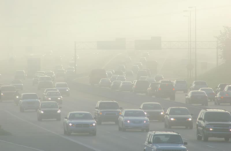
Floods, Droughts, Then Fires: Hydroclimate Whiplash is Speeding up Globally

DRI’s Christine Albano co-authored a new study that examines how a warming climate is creating an atmosphere more prone to extreme weather. This “hydroclimate whiplash” is evident in California’s recent weather, with winters filled with repeated atmospheric river storms driving the plant growth that the dry summers then parched, providing plentiful fuel for explosive wildfires.

Map of the western United States that shows you can click on Tribally controlled regions for more information.

New Climate Projections Released for Tribal Lands

Earth’s climate future is often discussed in terms of degrees of warming, but for farmers and ranchers, temperature is not the only metric that matters. Other variables such as the number of frost-free days, timing of first snowfall, or changes in spring and summer precipitation are critical to planning future planting, growing, irrigating, and harvesting activities. To help Native agricultural producers prepare for the changes to come, Native Climate has compiled detailed local climate projections for 633 tribally controlled areas in the United States, including Alaska Native Villages and State Designated Tribal Areas, and climate divisions for the State of Hawai‘i.

Landscape that includes people standing on a large ice sheet with hills and dark clouds in the distance.

Ice Patches on Beartooth Plateau Reveal How Ancient Landscape Differed From Today’s

DRI scientists Joe McConnell and Nathan Chellman co-authored a new study that examines a 6,000-year-old forest preserved in a Rocky Mountain ice patch. The research, which was led by the USGS and Montana State University, used the fossil wood to develop tree-ring based temperature estimates of the mid-Holocene period. The study can provide insight into the future elevational movement of forests under climate change, the scientists say.

Reno Sparks Heat Mapping Project logo over a picture of the city of Reno.

Reno-Sparks Heat Mapping Project Releases Detailed Urban Heat Data 

The summer 2024 data collection effort provides community members, legislators, and scientists with detailed maps of the region’s urban heat island. The campaign took place on August 10th, a clear and hot day for our region. The measurements and maps produced from the campaign reveal a great deal of variability across the nearly 200 square miles of our study area and between the early morning, mid-afternoon, and early evening time periods of the study. 

Landscape of Grass covered mounds in the United Kingdom with long grass in the foreground.

Lead Pollution Likely Caused Widespread IQ Declines in Ancient Rome, New Study Finds

Lead exposure is responsible for a range of human health impacts, with even relatively low levels impacting the cognitive development of children. DRI scientists have previously used atmospheric pollution records preserved in Arctic ice cores to identify periods of lead pollution throughout the Roman Empire, and now new research expands on this finding to identify how this pollution may have affected the European population.

Satellite Image of Simushir Island covered in snow and ice surrounded by the Pacific Ocean.

New Research Solves 200 Year Volcanic Mystery

DRI scientists Joe McConnell and Nathan Chellman are co-authors on a new study that sheds light on a historical mystery that has plagued historians and scientists alike for nearly two centuries. Using Arctic ice core records, the team identified the volcano responsible for an enormous eruption in 1831 that caused global cooling of around 1°C, leading to crop failures and famines around the world.

Thick smog hovers over a highway during rush hour traffic.

Regional, Racial, and Economic Disparities in Cancer Risk from Air Pollution Exposure Persist, But Improving, New Research Suggests 

Researchers from DRI and UNR teamed up for this new study, published October in Environmental Science & Technology. Using sociodemographic data from the U.S. Census Bureau and public health and air pollution information from the EPA between 2011 and 2019, the study identified higher estimated cancer risk tied to air toxics in urban communities, those with lower incomes, and those with higher proportions of racial minorities. 

On top of a cliff overlooking the ocean at Point Reyes with a walking path and wildflowers.

Groundwater is Key to Protecting Global Ecosystems

New research identifies ecosystems around the world that could be threatened by declining groundwater levels. The research, published July 17 in Nature, is the first time that groundwater-dependent ecosystems have been mapped on a global scale. Led by scientists from The Nature Conservancy and DRI, the global effort brought researchers together from universities, non-profit organizations, and institutions from seven countries.