Early warnings for atmospheric river-induced flooding are greatly improved by accounting for the impact of saturated soils.
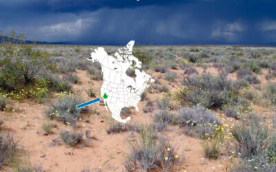
Reno, Nev. (Feb. 27, 2026) – Atmospheric rivers carry unfathomable amounts of water across the sky, bringing moisture to drought-stricken regions like the Western U.S. But whether a particular incoming atmospheric river storm will result in disastrous flooding has long been difficult for researchers to determine with confidence. Now, a new DRI-led study demonstrates that accounting for soil saturation levels can substantially improve our early warning of potentially destructive flooding events.
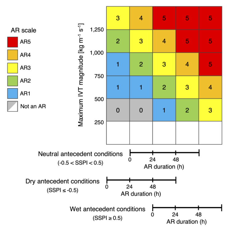
The research, published February 12th in Nature Communications, was led by DRI hydrologist Mariana Webb. She and her team examined more than 71,000 atmospheric river storms in the Western U.S. and central Chile to improve flood hazard early warning. The existing atmospheric river scale — which ranks storms on a spectrum from primarily beneficial to primarily hazardous — is based solely on the size and duration of the storm. By incorporating soil saturation levels at the time of a storm’s landfall, Webb doubled the correlation between storm rank and flood outcome and increased the number of flood-generating storms classified as hazardous by over 25%. With these changes, meteorologists could accurately predict flood hazard potential for about 87% of storms in California and 72% of storms in Chile.
“My view as a hydrologist is that we really needed to include processes happening at the land surface — is the soil absorbing incoming moisture like a sponge, or is that sponge saturated and causing elevated stream flow?” Webb said. “And when we did that, we found significant improvements in the scale’s ability to identify flooding hazards.”
The research can strengthen our early warning systems for flooding and help reduce storm damage, estimated at around $1.1 billion annually on the West Coast of the U.S. alone. It could also help water managers better prepare reservoir systems to ensure that as much water as possible is captured to sustain the region through the long dry season without increasing flood risks.
To account for soil saturation levels, Webb and her team created a simple proxy based on the amount of precipitation that fell over the previous 90 days. Because this information is widely available, the approach can be used even in areas without soil moisture observation data. When recent precipitation indicates especially wet conditions, the atmospheric river scale is adjusted upward to reflect the higher flood hazard potential of the storm. When recent precipitation is low, the scale is accordingly adjusted downward.
“The elegance of Dr. Webb’s approach is that it combines two early warning indicators – incoming atmospheric rivers and land conditions on the surface – in a framework that is simple, familiar, and does a better job representing potential flood risks than either of these can do in isolation,” said Christine Albano, Associate Research Professor of Hydrology at DRI and co-author of the new study.
Both the Western U.S. and central Chile receive frequent atmospheric river storms that carry moisture from the tropics to Earth’s mid-latitude regions, prompting Webb to spend time working closely with study collaborators in Chile to refine flood early warning systems for both regions.
“The comprehensive analysis led by Dr. Webb shows that similar atmospheric river storms can produce very different flood impacts depending on how wet the land is before the storm,” said Deniz Bozkurt, Professor of Meteorology at the University of Valparaíso, Chile, who co-authored the research. “In central Chile, as in California, atmospheric rivers are a major source of seasonal water but also a main driver of damaging floods, making accurate understanding of their impacts essential for anticipating flood risk.”
Now a postdoctoral scholar with the Center for Western Weather and Water Extremes (CW3E) at the University of California, San Diego, Webb hopes to operationalize the modified atmospheric river scale to support early warning systems and provide more localized information about the potential impacts of an incoming storm.
“Incorporating the best available soil moisture information, as in the work led by Dr. Webb, provides critical context about how a watershed is likely to respond to an incoming atmospheric river,” said Anna Wilson, Assistant Director for Atmospheric River Reconnaissance at CW3E who co-authored the research. “This added perspective supports more actionable hazard outlooks, helping emergency managers, reservoir operators, and communities make earlier and more confident preparedness and management decisions for their locality when an atmospheric river is forecast.”
As extreme weather becomes increasingly common, the research illustrates how hazard classification tools can be improved by considering their interaction with the land surface. “This opportunity extends beyond atmospheric rivers to include other weather hazards where conditions on the ground shape hydrologic outcomes, including snowmelt-driven floods, post-wildfire erosion, or flood risks exacerbated by reservoir levels,” Webb said.
—————————————————————————————————————
More information: The full study, Antecedent moisture enhances early warning of atmospheric river flood hazards, is available from Nature Communications at https://www.nature.com/articles/s41467-026-69286-3
Study authors include: Mariana Webb (DRI), Christine M. Albano (DRI), Deniz Bozkurt (Univ. of Valparaiso), René D. Garreaud (Univ. of Chile), Anna M. Wilson (U.C. San Diego), Guo Yu (DRI), Michael L. Anderson (CA Dep. of Water Resources) & F. Martin Ralph (U.C. San Diego)
About DRI
We are Nevada’s non-profit research institute, founded in 1959 to empower experts to focus on science that matters. We work with communities across the state — and the world — to address their most pressing scientific questions. We’re proud that our scientists continuously produce solutions that better human and environmental health.
Scientists at DRI are encouraged to follow their research interests across the traditional boundaries of scientific fields, collaborating across DRI and with scientists worldwide. All faculty support their own research through grants, bringing in nearly $5 to the Nevada economy for every $1 of state funds received. With more than 600 scientists, engineers, students, and staff across our Reno and Las Vegas campuses, we conducted more than $59 million in sponsored research focused on improving peoples’ lives in 2025 alone.
At DRI, science isn’t merely academic — it’s the key to future-proofing our communities and building a better world. For more information, please visit www.dri.edu. To support our work pursuing science that matters now, visit www.dri.edu/donate.
Media Contact
Elyse DeFranco
Lead Science Writer & Public Information Officer
elyse.defranco@dri.edu