Climate Engine is partnering with the Bureau of Land Management (BLM) to guide drought planning on BLM-managed lands with support from NOAA’s National Integrated Drought Information System (NIDIS)
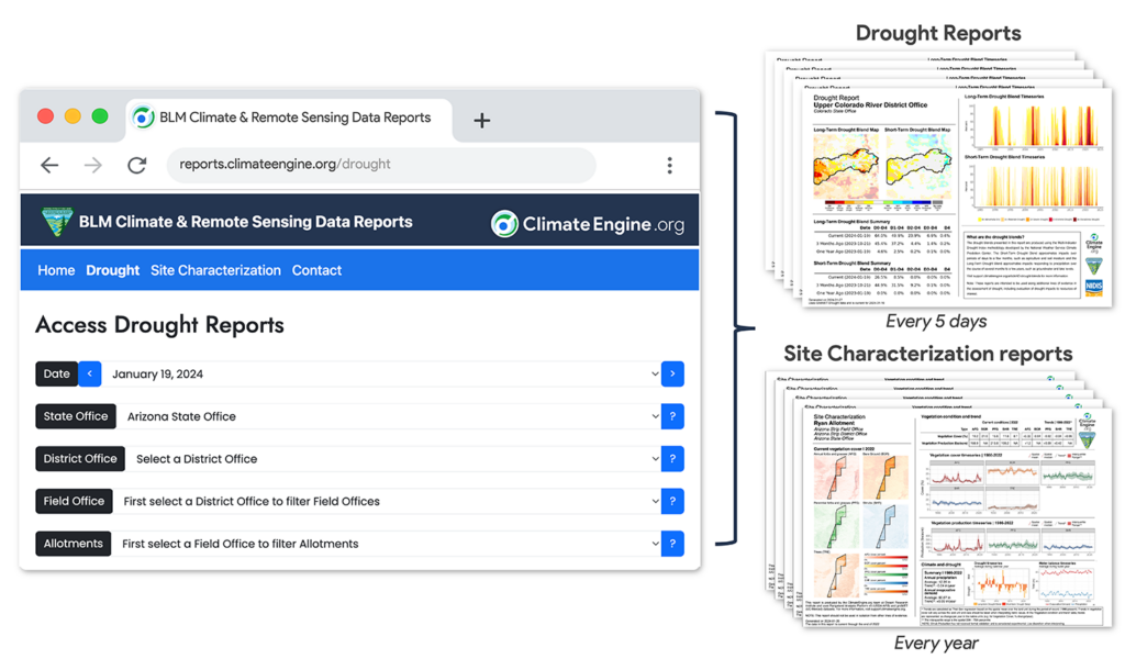
Reno, Nev. (March 13, 2024) – ClimateEngine.org is an innovative tool that provides satellite and climate data in a user-friendly manner to facilitate water conservation, wildfire risk management, agricultural productivity monitoring, and ecological restoration. Created through a partnership between researchers at Desert Research Institute, the University of California Merced, Google, the National Oceanic and Atmospheric Administration, the Bureau of Land Management, and other federal partners, Climate Engine allows users to create maps and time series plots for visualizing complex climate data. Now, the team is launching a new publicly accessible platform designed to produce comprehensive and detailed reports for all BLM-managed lands in the contiguous United States. The reports combine scalable drought summaries and near real-time vegetation conditions to help inform planning and decision-making.
“The goal of this new platform is to lower the barrier to using timely drought and satellite-based vegetation datasets for resource managers,” said Eric Jensen, geospatial data scientist at DRI. “We have worked closely with the BLM Aquatic Resources, Assessment, Inventory, and Monitoring, and Rangeland Management Programs to identify relevant drought indicators, make it easy for managers to pinpoint the land unit they’re interested in, and download a simple report that they can use for reporting and decision-making processes.”
The website provides both drought and site characterization reports that assess drought indicators and satellite-based vegetation cover and productivity over time, with data extending back to 1986 based on the Landsat satellite archive. All reports are publicly free to view and download, which builds transparency into the decision-making process.
“The BLM manages around 245 million acres of land, more than any other federal agency. Having these data not only readily available, but in a usable form, will directly contribute to our mission of responsibly managing environmental, cultural, and historical resources across the country,” said Paula Cutillo, National Water Resource Specialist with the BLM. “The sustained and unprecedented drought currently impacting the Western U.S. challenges sustainable resource management, and we are increasingly considering drought severity, water availability, and drought resilience when making land use decisions. We need all of this information to make balanced, forward-looking decisions in a changing climate.”
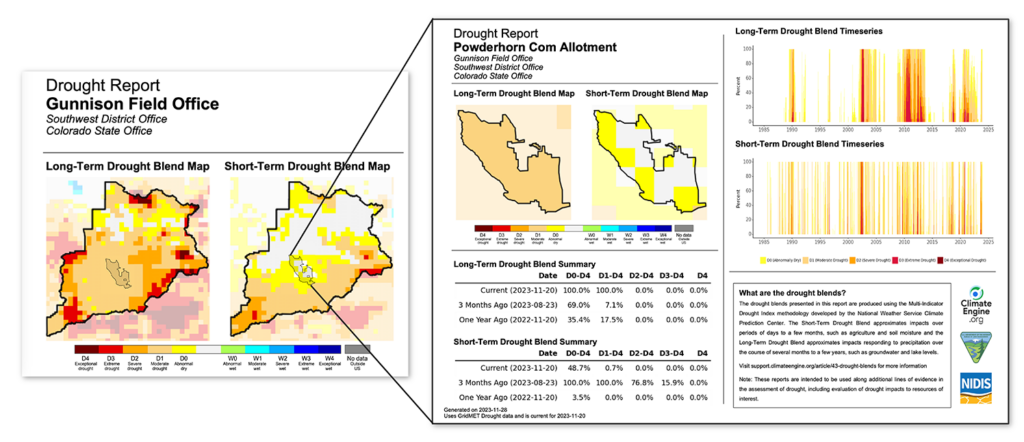
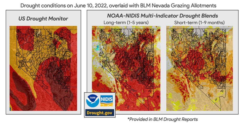
The Climate Engine team partnered with NOAA’s National Integrated Drought Information System (NIDIS) to provide multiple drought indicators at higher spatial resolution than what is available through the U.S. Drought Monitor. Users of the new site will see both long-term (up to 5 years) and short-term (up to 9 months) drought information that combines several drought monitoring indices into a single map at decision-relevant scales. Longer-term drought can impact groundwater and reservoir levels, while shorter-term impacts may include drier soils and reduced plant growth. These tools can allow for more precise and directed drought response and management plans. Satellite-based vegetation data is provided through the Rangeland Analysis Platform, with support by the USDA Agricultural Research Service. All data included in the reports are presented in clear, visually appealing maps and graphs, and drought reports are updated every five days.
“NIDIS has promoted the use of Climate Engine within BLM since 2018, and we believe that this new tool will further empower decision makers to use the best available data for their land planning decisions,” said Steve Ansari, U.S. Drought Portal Manager and physical scientist with NOAA’s National Centers for Environmental Information. “These drought reports provide a nearly real-time snapshot of drought conditions at each land unit and are capable of capturing a lot more detail at a scale that supports BLM decisions.”
Future updates and improvements to the platform will include expanded vegetation production reports to further support land use planning and decisions, developing additional drought indicators, and including information about fire history as well as wildfire risk.
Users can refer to detailed guidelines for using the reports, including tutorials and information about the datasets and metrics used, trouble-shooting tips, and answers to frequently asked questions at Support.ClimateEngine.org.
###
About Climate Engine
ClimateEngine.org is a collaboration between DRI, University of Merced, Google, and federal partners. The science team includes: DRI researchers Justin Huntington, Britta Daudert, Jody Hansen, Eric Jensen, Thomas Ott, Kristen O’Shea, Charles Morton, and Dan McEvoy as well as UC Merced researchers Katherine Hegewisch and John Abatzaglou. Find out more about the initiative, partnerships, and updates at ClimateEngine.org and Twitter @ClimateEngOrg, and see the initiative’s peer-reviewed publication.
About DRI
We are Nevada’s non-profit research institute, founded in 1959 to empower experts to focus on science that matters. We work with communities across the state –and the world– to address their most pressing scientific questions. We’re proud that our scientists continuously produce solutions that better human and environmental health.
Scientists at DRI are encouraged to follow their research interests across the traditional boundaries of scientific fields, collaborating across DRI and with scientists worldwide. All faculty support their own research through grants, bringing in nearly $5 to the Nevada economy for every $1 of state funds received. With more than 600 scientists, engineers, students, and staff across our Reno and Las Vegas campuses, we conducted more than $47 million in sponsored research focused on improving peoples’ lives in 2023 alone.
At DRI, science isn’t merely academic – it’s the key to future-proofing our communities and building a better world. For more information, please visit www.dri.edu.
Media Contact:
Elyse DeFranco
Science Writer, DRI
E: elyse.defranco@dri.edu